Friday, May 22, 2009

Michael Palin to head up the RGS!


Well travelled - 105/365
Originally uploaded by alexjcrawford.
From Emma Quilligan:
On June 1st, Michael Palin will be named as the new president of the Royal Geographical Society. The former Monty Python star has been travelling the world for more than three decades and says that his love of geography stems from school field-trips as a boy in Sheffield. He may therefore use his new position to promote geography in schools, previously arguing that the subject should be made “relevant, lively, stimulating, adventurous and…fun.


Oh SQUEE. Just SQUEE.

I love what I call "Palin's geography stuff." His *delight* with it -- his response to locals, his enthusiasm, his pure amateur joy at discovery -- is one of those things that helps feed my own, like John McPhee's, or David Attenborough's.

*SQUEE*

buuz!

This is really a beautiful article in The Atlantic Monthly:
The Hearty Food of Mongolian Winter.

Perhaps as much as with any National Geographic story, I felt like I had a sense of what hanging out in a Mongolian home is like.

Sharing water in the Klamath Basin

Dangit, I finally just got the Klamath Water Wars book (Water War in the Klamath Basin: Macho Law, Combat Biology, and Dirty Politics) as a birthday present from my friend Sue ... and now, finally, the war is over. No?

The Klamath Tribes and farmers have agreed to drop their state water rights battle pending approval of a federal agreement leading to removal of dams on the Klamath River.
The settlement filed Wednesday with the Oregon Department of Water Resources mirrors the water issues in the dam removal plan, known as the Klamath Basin Restoration Agreement.

(there's more at that link)

There's so little water in that area, and so much life depends on it -- salmon, migrating birds, farmers, ranchers, the water table.

The current cessation of hostilities is "pending approval of a federal agreement leading to removal of dams on the Klamath River." I'll certainly continue reading the book, and hope for the best.

Thursday, May 21, 2009

Monday, May 18, 2009

Earth from the Space Shuttle


s26_5e007774
Originally uploaded by marymactavish.
Wow! Check out these fabulous cloud photos from STS-125, the final Hubble servicing mission.

I found them on boston.com's The Big Picture.

Some are NASA photos (and thus free to use with attribution) but some are copyrighted to Getty, AP, and at least one private individual.

s22_5e007547

I love the way the clouds in the streaky, mackerel-sky photo outline the west coast of Baja so beautifully, and the swirls in sea over . . . where is that? Africa?

Click through to The Big Picture to see more photos, including the non-NASA photos, and a great display of some of the tools the astronauts use -- and all the pictures are (of course) BIG.

This mission has driven me to nail biting and tears more than once. I love it. I am captivated. I envy the folks who get to do the EVAs, am sorry for those who aren't. I cheer Megan, who is from my area, and Drew, who is just the epitome of grace under pressure. And today, when John Grunsfeld knocked the cap off of an antenna, I carried my laptop around to do a few things I had to do around the house, because I couldn't leave the live feed, my heart was in my throat in sympathy with poor John. "I feel sick," he said. But they let him fix it, and he did, and everything's fine now.

Go John.

Go Atlantis and your crew, go Hubble.

Go human exploration of space.

Saturday, May 09, 2009

Random stack of books?

Well ... Semi-random.

These are on my official Geography Table, thus the subject matter. But books like these comprise maybe 20% of my entire large book collection.

oh what the hell, have some geonerd books on Twitpic


When I get my geopictures on the wall behind the table, I'll take books and blog about my geography table specifically, and why it's special. I just snapped this picture a minute ago and figured I'd share.

Friday, May 08, 2009

Jesusita fire from the air, with MODIS helping


2009_05_08_jesusita_041
Originally uploaded by dsearls.
The caption says:
"A view of MODIS fire detections, looking east-northeast and across the fire perimeter from about 25,000 feet above Goleta. A new hot spot shows in the canyon above Patterson Ave, near some orchards (or vineyards) above San Jose Creek. Of more interest are the other new hot spots approaching Painted Cave, on the other side of 154 and near the ridge."

Click through to embiggen and comment for the mapper, of course.

I've lost count of the number of people calling it, "Jesus, it's a fire!" with the implied "Get in the car!"

Thursday, May 07, 2009

The Geography of the Jesusita Fire

Of all the fire articles I've read in a long time, this one caught my interest differently than the others, and I read it with a fresher eye.

Ray Ford's article in the Santa Barbara Independent looks a little at the rugged residents and the rock-tough firefighters, but it also touches on the wind, the topology, the vegetation, and other things that drive a fierce wildfire in California's chapparal.

This is geography. It's not just about what burns, or why, but about how it all works together, and anyone
who really wants to study fires, damage prevention, and effective fire-fighting in California probably knows all of this:
"Then without warning, the wind shifted, catching everyone by surprise. The shift was sudden and intense. Within a minute it switched from a 10-to-15MPH steady uphill breeze to 50MPH storm force winds heading directly down canyon."

And that, yesterday, is why the apparently mild-mannered Jesusita Fire went crazy, and is still out-of-control along Santa Barbara's northern flanks. The mandatory evacuation order includes areas just north and west of Santa Barbara's downtown. Flickr has plenty of pictures so far.

Google Maps has some LA Times coverage including where homes have burned, and links to stories.

Monday, May 04, 2009

Going Meta


Blogging Research Wordle
Originally uploaded by Kristina B.
I started this blog for reasons very like Anne Minard's. It took me awhile really to get going, and I go on runs for bits of time. Then other times, writing ideas fizzle or I can't think of a way to make them geographilic (for awhile, I considered having one day devoted to related sciences, such as cosmology and astronomy, or environmental advocacy, and still might), or I get incredibly busy with non-internetty things like the garden, or the big family wedding coming up, and I don't keep up. I try to front-load with posts that aren't timely, but I don't want to throw meaningless drivel up here too often, either.

I'd appreciate knowing whether you read this blog, and if so, why, and what sorts of writing here most interest you. That will help me guide further posting. There might still occasionally be photos of baked clay squids with earths on their backs, though.

Saturday, May 02, 2009

Burakumin children fleeing an angry mob (and modern context, too)

According to an AP story, Google included some old David Rumsey-archived maps of Tokyo in Google Earth's recent historical maps layer, including those that showed historic Burakumin.

The Burakumin were (are, in some minds) a very low caste of people who traditionally worked in fields that were related to death, such as grave-digging and tanning leather.

But that was centuries ago, right? According to modern leaders of communities of Burakumin descendants, having their historic neighborhoods visible in Google Earth is discrimination, or at least, facilitates it:

[Google] is now facing inquiries from the Justice Ministry and angry accusations of prejudice because its maps detailed the locations of former low-caste communities."
[...]
Castes have long since been abolished, and the old buraku villages have largely faded away or been swallowed by Japan's sprawling metropolises. Today, rights groups say the descendants of burakumin make up about 3 million of the country's 127 million people.

But they still face prejudice, based almost entirely on where they live or their ancestors lived. Moving is little help, because employers or parents of potential spouses can hire agencies to check for buraku ancestry through Japan's elaborate family records, which can span back over a hundred years.

An employee at a large, well-known Japanese company, who works in personnel and has direct knowledge of its hiring practices, said the company actively screens out burakumin job seekers.

"If we suspect that an applicant is a burakumin, we always do a background check to find out," she said....

Lists of "dirty" addresses circulate on Internet bulletin boards. Some surveys have shown that such neighborhoods have lower property values than surrounding areas, and residents have been the target of racial taunts and graffiti. But the modern locations of the old villages are largely unknown to the general public, and many burakumin prefer it that way.

Google Earth's maps pinpointed several such areas. One village in Tokyo was clearly labeled "eta," a now strongly derogatory word for burakumin that literally means "filthy mass." A single click showed the streets and buildings that are currently in the same area.

Google posted the maps as one of many "layers" available via its mapping software, each of which can be easily matched up with modern satellite imagery. The company provided no explanation or historical context, as is common practice in Japan. Its basic stance is that its actions are acceptable because they are legal, one that has angered burakumin leaders.


Much more detail is available at the link.

Google has, with the help of David Rumsey, removed information about these neighborhoods from the current updates for Google Earth.

It was Rumsey who worked with Google to post the maps in its software, and who was responsible for removing the
references to the buraku villages. He said he preferred to leave them untouched as historical documents, but decided to change them after the search company told him of the complaints from Tokyo.

"We tend to think of maps as factual, like a satellite picture, but maps are never neutral, they always have a certain point of view," he said.

Rumsey said he'd be willing to restore the maps to their original state in Google Earth. Matsuoka, the lawmaker, said he is open to a discussion of the issue.


I find myself wishing I'd re-installed Google Earth after I re-installed Windows a few weeks ago. I figured I would as soon as I wanted to use it, but now I want to look without updating, and see the older maps. Maybe a poke around David Rumsey's site would do the trick.

Still: I want to see it as a layer, in context, but perhaps, as the Japanese hope, with historical context given as well. Every modern nation has some history that needs a better light shined its way, Japan included.

women in science - geology

This portrait of geologist Florence Bascom is part of the fabulous Women of Science set in the Smithsonian's flickr stream.

There are some photos in there with names and some description, but not enough information. The Smithsonian is requesting the help of flickr users in gathering more information about the scientists in the pictures.

Friday, May 01, 2009

map and globe vocabulary


I like reading maps and atlases written in different languages, both for the varying names of countries and features, as well as different words for basic map terminology.

irrigation system


irrigation system
Originally uploaded by marymactavish.
In the middle of the summer, this area can get a tenth of an inch of rain a month. Mostly, it pours (if we're lucky) mid-winter, and is dry all summer. The occasional thundershower might punctuate the endless browning of the grass, the cracking of the clay soils. When clouds come in like they did last night, I just assume it's the marine layer, fog. But I heard raindrops on the old stovepipe in the roof this morning, looked out, and YAY! Rain! The crops are saved!

(Also: I always say "rain, the crops are saved" because of the old shampoo commercial from the seventies that no one else remembers.)

Yay, Mediterranean climate. Yay, occasional interrupting shower, so I don't have to use the brand new irrigation system today.

Wednesday, April 29, 2009

Phoebe and Sophie are geographiles

And they want you to know why they think geography is important:


I really love student videos. :D

Sunday, April 26, 2009

This almost makes me want an iPhone

I really love my Palm Treo, but the interface of the iPhone allows games . . . I mean, um, learning tools like this, in ways Palm's interface can't.

I have no idea how well this app works, I've never tried it. I have no connection with the company that makes it. I just want to play with it.

Saturday, April 25, 2009

Yann Arthus-Bertrand makes art from the air


Yann Arthus-Bertrand
Originally uploaded by Wa-J.
Yann Arthus-Bertrand takes some of the most beautiful aerial photos I've ever seen, most of them from the Ultralight aircraft he sails over the earth with.


Click through to the link for a lot more of them.

Friday, April 24, 2009

satellite alphabet


alpha-map670-thumbnail
Originally uploaded by marymactavish.
This is just beautiful.

Designer (creative director) Rhett Dashwood poked around on google maps for Victoria, Australia, and came up with an entire alphabet. I thumbnailed it for blogging, but am leaving you to go see the big version on his own website.

I need to take a little time and do one of these on my own. What fun.

The original page and much bigger image are right here at rhettdashwood.com.au.

Wednesday, April 22, 2009

Atlas


Atlas
Originally uploaded by Articulate Matter.
I have no words.

Tuesday, April 21, 2009

Get outside! But come back and tell us what you saw.


Coyote, Death Valley
Originally uploaded by marymactavish.
Oh, this is a nifty site.

Wildobs lets you upload the location of wildlife you find around North America (at least) with details about habitat, and mapped locations. I am going to explore the area near where I live, find out what's around at this time of year that I haven't yet noticed, and go look. It's a perfect "get outdoors now!" computer toy. (There's an associated iphone app, too. I don't see anything for my Treo yet.)

Monday, April 20, 2009

fussing about the weather


scorcher
Originally uploaded by glennbphoto.
The San Francisco bay area usually has relatively moderate weather, with the occasional scorcher in July or August. This is the first time I can remember three days in a row like this in April.

The thing is, only houses built since the mid-70s routinely have insulation, and far fewer than that have air-conditioning. Our house has no insulation at all, and despite having a patio on the south side and small windows on the west side, we can spend much of a warm day 5ive to ten degrees hotter indoors than outdoors. We start the day, on days like this, with fans at about 6 am. When the air blowing in goes from neutral to warm, we shut off fans, close windows, close up the master bedroom with the tiny in-room a/c unit, and hang out together in the one room. On a 95 degree day, that bedroom can be kept at about 80, while the hallway will be 86 or so, and the rest of the house at 90-100.

The blessing is that it's not humid. One of my most miserable days was in June 2006, in Boston, when it was 100F outside, 90% humidity. And just as a warning: There's nothing worse than smelling the tar decks of the USS Constitution on a day like that, then going to a kosher deli/restaurant and watching a waiter carry a pile of wiggly gravy-covered meat loaf past your table.

But I digress.

Here, it's about 93F right now, but humidity is in the mid-20s. It's starting to feel cooler outside than inside so I've reopened the house and turned the fans back on. I'm lying around, typing and sweating, with an ice pack between me and the laptop. It's not so bad.

We look moderate on paper partially because though we have days like today, the forecast for Friday is in the high 50s with a chance of rain, and just this time last week, I took this little video 20 miles from here, on a chilly afternoon.

(Photo was taken in San Francisco yesterday. It's possible the sensor was in the sun.)

Sunday, April 19, 2009

California's new Geospatial Information Officer explains what the GIO office is for.


On April 14, Michael Byrne, the new GIO for the State of California, explained the duties of the GIO office, and his position.

It seems like the right move, now, with so much of what happens in California facilitated by mapping and aerial photography, to integrate agencies and services with shared GIS directions and resources.

In which I share a little of my life


Plenty
Originally uploaded by magic fly paula.
Sometimes, simply repeating a conversation sums everything up.

I love google. I love knowing where to find information. And I can't not know some things. This then comes back to my obsession

I had this instant-message conversation, just this morning:
(11:09:33 AM) Me: Casey asked me if the strait of gilbraltar were closing or opening -- I didn't know for sure.
(11:09:42 AM) Kimberly: : heh, no clue
(11:10:01 AM) Me: So now: Would you like to know about the geology of northern africa and the african/eurasian plate boundary? I had to find out.
(11:11:02 AM) Kimberly: : of course I would like to know!
(11:20:10 AM) Me: *grin* The African plate is moving north pretty fast, but most of the compression is happening in (causing, in fact) the Atlas Mountains, not closing the straits.
(11:20:49 AM) Me: The straits gradually opened from about 25 million years ago to 5 myo, but have been slowly, slowly closing since, with most of the compression happening elsewhere in the mediterranean, local N. African mountains, and 45% of it in the Atlas Mountains.
(11:21:43 AM) Me: I said to Casey, "You knew I couldn't not know, once I realized I didn't know." Casey said, "I know. It means I don't have to do my own research."
(11:21:52 AM) Kimberly: : lol


I'm sure some of the information is vague and/or inaccurate, and I certainly provide no citations. It was based on 15 minutes of reading from links I found via google. But still: This is how my life often goes.

Wednesday, April 08, 2009

Volcanos sound like airplanes


Cotopaxi Quito plane tourism
Originally uploaded by hyperscholar.
Really.

Listen

Witnessing for ... Geohovah?


I used to know someone who kept a stack of books -- KJV (which he'd read through, and studied), probably the Jerusalem Bible, books on Paganism, the Book of Mormon, Buddhist texts, all sorts of things -- in a stack on the table next to the front door. He was an obsessive reader of psychology and theology, and every time something caught his eye at a book sale, he'd bring it home, and devour it. When folks wanted to come in and talk religion, he could do that, and did, and would sit them down for an hour or more to discuss things they weren't always ready to discuss. He'd pick up his books and leaf through until he found a relevant passage, read it, and bring it into the conversation. The proselytizers never managed to convert him from basic agnosticism, but it passed the time for him, and he liked meeting new people.

If this Geohovah's Witness guy showed up at my door, I'd take him to my special geography table and show him my atlases, geography texts, books about water policy and fire control in chaparral and bird identification and food politics in developing nations and plate tectonics and biodiversity, and of course, offer him coffee and cookies and we'd chat.

I must sound like him sometimes. I can't drive down Mission Bl. through Hayward, in California, without pointing out the Hayward Fault scarp. I can't be along the marine terraces of Highway 1 without explaining how they were formed. I especially can't see serpentine soil (or serpentinite) without getting into a discussion about its formation and ecology.

Water towers in Alameda County -- the kinds that used to sit in back yards, and hold water pumped up from the ground with windmills, for the households -- fascinate me endlessly. Can I control my urge to tell people about them, if they don't already know? No, not really.

I am a geography evangelist. I think I must annoy my friends sometimes. They say they don't mind, but I wonder.

(This sounds like I don't get the point of the video. I do, it just got me musing.)

Tuesday, April 07, 2009

zappos - the map


Travel Sponsor: Zappos
Originally uploaded by theritters.
Another quickie, just because I'm so charmed by the Zappos shoe map that I can hardly stand it: http://www.zappos.com/map/

This isn't meant to be a Zappos ad, I like the company but don't have any vested interest in them at all, and am not any sort of shoe-diva. I am just in love with that map, the concept, the execution, the sheer for-the-sake-of-it goodness.

Friday, April 03, 2009

highly perfect basal cleavage


highly perfect basal cleavage
Originally uploaded by Twm™.
I'm celebrating South Africa's National Cleavage Day in a geographilic way. Yay.

Wednesday, April 01, 2009

Basic map stuff - How colors are used


Years ago, in physical geography, we had to color in a physiographic map of the United States. I loved that activity, with colored pencils, and thin pens, and geology references. The teacher told us that we could choose our own colors, and one student showed him her map with the sea colored orange. He said, "I know I told you that you can choose your own colors . . . but just no. No. The sea cannot be orange." And he had her start over. It was sad, but . . . just no.

Sunday, March 29, 2009

lightning at Redoubt Volcano

I titled a previous post "that's right it starts with an earthquake, birds, snakes, and aeroplanes," and it's tacky to do that again, and so I won't.

Instead, I'll just give you this, a whole set of Redoubt photos, most showing the eruption, and a few, like this, with dramatic lightning.

I wouldn't mind watching this, with protection from the ash, and some distance.

Wow.

I did not take this photo, it comes from the Alaska Volcano Observatory.

Wednesday, March 25, 2009

Me and California


2009-03-25 Mary and California
Originally uploaded by juverna.
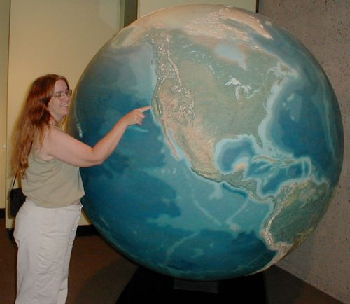
And yet a bit more fluff .... but this is me. And this is me doing what I always do when I encounter a big map. I have to touch it (if I can) and find recognizable features, and talk about it, and triangulate.

This is a big, flat map without most labels, and I had to wander around it and talk about it, and tell my companion about the White Mountains and the Bristlecone Pines, and (here) the various drainages of the Feather River, and about the Sutter Buttes and how they're a tiny mountain range, and we had to find the original Brokeoff Mountain remnants around Mount Lassen, and I could have stayed and looked at it for another thirty minutes or so.

I want this for my house. Is that too much to ask?

It's near the climate change exhibit at the California Academy of Sciences in Golden Gate Park. Go check it out. Say hi for me.

"Daylight Savings brings back Rose, the two o'clock titty."

http://www.nbcbayarea.com/around_town/the_scene/SF-Cathedral-Hosts-Topless-Peepshow.html (worksafe, geographilic)

(quickie, sorry -- off to do naturey things, more substantive post tonight)
(and yes, shadows cast on the earth by the sun are pure geography)

Friday, March 20, 2009

Behold: The Ice Worm

As glaciers on the west coast of North America melt, we will lose countless millions, or even billions of representatives of a creature that lives only in those west coast glaciers.


Mind you, these are just the ice worm. We'll also lose alpine plants and animals that have migrated to as high and cool as they can go or as dry as they can go, water storage in snowpack and glaciers, riverflow, and some existing air circulation patterns. More will be revealed. We shall see, we shall see.

Thursday, March 19, 2009

Tonga's doing a little remodeling


Underwater Volcano Tonga
Originally uploaded by roan lavery.
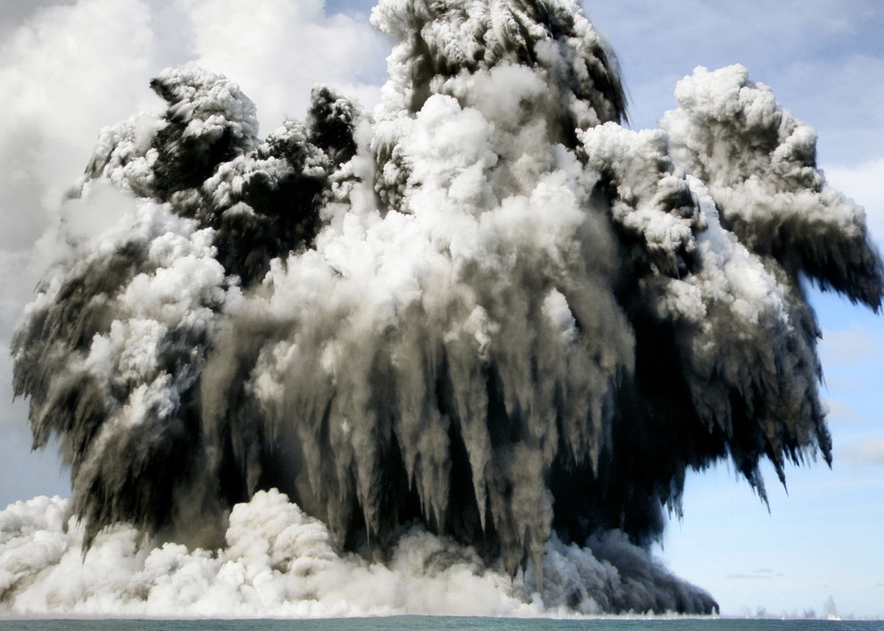
Near Tonga, last week, a volcano exploded with an earth-shattering kaboom from below the sea.

I love the shapes and drama of the black, white, and grey of the ash, steam, and other ejecta.

Boston.com's The Big Picture has some pictures that made my heart pound. I actually made a squeak when I saw #10.

There's no real evidence at this point that the volcano is related to today's quake, and it almost certainly isn't.

.

I love this planet. This is an awesome planet.

Sunday, March 15, 2009

totally random find while stumbling around in slow motion videos on youtube


Holy cow this is amazing lightning video! The annotations label the various leaders.

I grew up in a part of California that has summer lightning storms, but even those amazing storms weren't like storms can be in other parts of the US and the world. Lightning still enthralls me, rather than scaring me.

I sat through one storm in Arizona, once, under shelter, watching the occasional distant glow of a transformer exploding under a strike. That was enough of the big stuff.

Monday, March 09, 2009

savoring the world, for now

When you're humming down a railway line in Germany, and you see the most intense rainbow you've ever seen before, what else is there to do but to take a picture through the grubby train window?

The most brilliant rainbow I've ever seen; picture taken this... on TwitPic
by @cosmos4u

I arise every morning torn between the desire to save the world and the desire to savor the world. It makes it hard to plan the day.
  -E B White

Saturday, March 07, 2009

those coincidences


Triple Rock
Originally uploaded by Ingorrr.
I stopped into Triple Rock brewpub in Berkeley, California tonight, for some of their Black Rock Porter (my all-time favorite beer) and what turned out to be the best hamburger I've ever had, anywhere. It wasn't a fancy burger at all, it just tasted perfect.

While I was there, a nice person turned to me and said, "Do you know anything about geography?" I cracked up and said, "You're kidding, right?" I'd already had a pint of beer, so wasn't thinking modestly or tactfully.

Then we spent a couple of hours doing his crossword (he wanted to know the largest country in Africa) and talking and drinking beer, and it was nice.

So *waves* to Elijah. Did I spell that right? I think so.

-Mary

Thursday, March 05, 2009

I just got my first-ever geographilic spam!


UN flag
Originally uploaded by gebauer.
In whole:

Congratulations beneficiary,

Your email has been selected by the united nations organization(UNO)for a
cash grant award of 1,000,000.00 USD(One Million Dollars). The united
nations authorities has decided to give this award to 15 beneficiaries
from all
over
the world to help facilitate the preparation of submissions to the Commission
on the
Limits of the Continental Shelf for developing States, in particular the
least developed countries and small island developing States,and compliance
with article 76 of the United Nations Convention on the
Law of the Sea.This grant is been aided by the united nations development
programme and the united nations trust funds for human security.
Your cash grant pin number is (UNO-154/4456/011)
Our corresponding office
in the (AU)African Union will give details on how
your funds would be remitted to you.Do contact our payment office immediately
with the information's below.
Full Name.
Address.
Age.
Sex.
Occupation.
Mobile Number.
House Number.
State.
Country.
******************************
A Scanned copy of a valid identification card should also be attached(either
an International passport or Driver's License) and send with the listed
information for claims of your won prize.
******************************
Payment Officer:Mr.Terry White
Phone Number:+234[redacted]
Email: unitednations.2009@[redacted, nothing resembling UN]
Regards,
Mr.Ban Ki-moon.

----------------------------------------------------------------
This message was sent using IMP, the Internet Messaging Program.


I know that can't be true. Ban Ki-Moon would never say "PIN number," as that is redundant.

Wednesday, March 04, 2009

Animaniacs - 50 State Capitals

Trying not to let the spelling of "capitals" in the youtube description get to me. Seriously.

Saturday, February 28, 2009

River processes


This is a pretty little school presentation.

Friday, February 27, 2009

Rock galleries on about.com

Andrew Alden of geology.about.com has been redoing his gallery of rocks, starting with igneous, but moving on to the other types eventually. You can visit his newly remodeled igneous section here, clicking down one layer will lead you to his current metamorphic and sedimentary pages, as well -- and eventually, to the redone versions.

I chose serpentine for this photo, because
1) it's in Oakland, and Andrew also does an Oakland Geology blog, which is fascinating if you're someone like me and
2) it's my all-time favorite rock. I've got a long and fancy serpentine post sitting there in notepad waiting patiently for me to finish it for this blog.

holy writing from my religion

At least, it's spiritual for me:

Poets say science takes away from the beauty of the stars -- mere globs of gas atoms.
I too can see the stars on a desert night, and feel them. But do I see less or more?
The vastness of the heavens stretches my imagination --
stuck on this carousel my little eye can catch one million year old light.
A vast pattern -- of which I am a part...
What is the pattern, or the meaning, or the why?
It does not do harm to the mystery to know a little about it.
For far more marvelous is the truth than any artists of the past imagined it.
Why do the poets of the present not speak of it?
What men are poets who can speak of Jupiter if he were a man, but if he is an immense spinning sphere of methane and ammonia
must be silent?
This was a footnote in one of physicist Richard Feynman's books, The Feynman Lectures on Physics. It's become one of my favorite poems ever.


(And I'm being a little silly, I don't really have science/nature/wonder as a religion, so much as that it's just a major source for things spiritual in my heart.)

Thursday, February 26, 2009

Philippine geography


Trying to come up with something important to say and all that occurs to me is "it's neat to hear the three languages work together like that."

Wednesday, February 25, 2009

To live is to learn, I can't imagine giving up curiosity


Swiped directly from Living Geography;
"... teachers are, first and foremost, public intellectuals. They really do need to 'know' something worthwhile, relevant and enjoyable to teach. That is why teaching is a graduate profession. Teachers need to have learned something, and in a dynamic subject like geography they need to keep learning."

Tuesday, February 24, 2009

Something called "volcano monitoring"


HDR After
Originally uploaded by linuxjunkiedotcom.
From Governor Bobby Jindal's response to President Obama's speech tonight:
That is why Republicans put forward plans to create jobs by lowering income tax rates for working families...cutting taxes for small businesses ...strengthening incentives for businesses to invest in new equipment and hire new workers...and stabilizing home values by creating a new tax credit for home-buyers. These plans would cost less and create more jobs.

But Democratic leaders in Congress rejected this approach. Instead of trusting us to make wise decisions with our own money, they passed the largest government spending bill in history - with a price tag of more than $1 trillion with interest. While some of the projects in the bill make sense, their legislation is larded with wasteful spending. It includes $300 million to buy new cars for the government, $8 billion for high-speed rail projects, such as a 'magnetic levitation' line from Las Vegas to Disneyland, and $140 million for something called 'volcano monitoring.' Instead of monitoring volcanoes, what Congress should be monitoring is the eruption of spending in Washington, DC.

(emphasis mine)

My guess is that cost him the vote, should he decide to seek the Republican presidential nomination for the 2012 elections, of much of southern Alaska, Washington, Oregon, and Northern California, and perhaps Hawaii too.

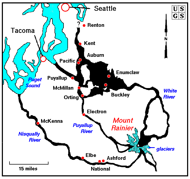
The towns southeast of Tacoma and Seattle, in Washington, are immediately downflow of Mount Ranier, and would receive the brunt of its mud, at the very least. Many towns in that area lie on existing mudflow. Monitoring the Cascades and other American volcanos protects western American cities as much as monitoring Atlantic weather protects southern and eastern cities.

Science really is important, and it worries me when it's brushed off as "something called 'volcano monitoring'," when it's treated like an elitist hobby. Americans can do it -- but not without good hard science.


(edited to add: Geologist Maria Brumm added the fiscal element: "I wish I'd thought of that.")

Lilly the map kid

I've read so much about Lilly, and whether she's just parroting information, or really "knows" this stuff. What is knowing, when it comes to labels? Aren't we parroting, too? Does it matter, if she's learning to be fascinated by maps?

Monday, February 23, 2009

Green Gabbro has excellent geology links


gabbro a smaragdite
Originally uploaded by marizerb.
As usual. And they are here.

Well, rats


nycmusnathistsubway0453
Originally uploaded by marymactavish.
This is a really sweet article, but makes me a little sad, because I "invented" the word geographile, and this usage is a good 15 years before I came up with it:
After his recent presentation to the Utah Geographical Society, he gave Brad a copy of "A Geolinguistic Handbook," engraved on the cover with "Brad R. Dennis, Geographile."


They ask at the end:

- Name the 10 largest countries.

- Name the 10 smallest countries.

- Name the 10 longest rivers.

- What are the new names of these countries: British Honduras, Dahomey, Upper Volta, Cambodia, Basutoland, Ellice Islands, Northern Rhodesia, Rhodesia, Congo, Dutch Guiana.

(They also answer those questions.)

A close one ...

Just wanted to show you a cool lightning picture. Please click through to the photo page for the photographer's explanation, cool notes on the image, and the fate of the trees.

GIS software recommendations needed.

A friend of a friend wants to do some GIS work involving health stats -- cause of death -- in a medium-sized town, with ability to map cause of death, and zipcode, and probably overlay them. I'm not sure of the details, and not very GIS-savvy. He's wondering what software's best. I know of ArcGIS. Any other recommendations? Feel free to ask questions, I'll answer if I can, and provide the asker links to this discussion.

(The poster is about potato blight. This is not related to cause of death.)

The Cinematic Geography of the Los Angeles area


I don't think Fox Plaza really blew up. There are a lot of reasons I wouldn't choose to live in Los Angeles. The first time I ever drove there, I had to find a friend's house in Hollywood at 1 am, I'd been driving only a few months, and her directions failed because 101 through Hollywood was closed for a movie filming. I had to make my way through city streets, without a map, without google maps on my Treo, hoping for the best, not knowing where I could stop safely. Fortunately, my habit of reading maps for fun gave me a basic understanding of LA geography and where I was headed, and my sense of direction and knowledge of main streets took me right to her apartment -- only two hours late.

Saturday, February 21, 2009

Festival of Linkage


USGS Entry
Originally uploaded by marymactavish.
This here linked video is interesting in its own right, but why am I linking it? The globe over James Randi's shoulder? Oh, how much do I want that globe? I want that globe very much.

Also:
The USGS feed on LiveJournal just exploded out a bunch of old link summaries, but there's some fascinating stuff there. Have a peek: http://syndicated.livejournal.com/usgsnews/ You don't need a LiveJournal account to read it.

Geography of American Elections

Geography of United States Elections -- time-eater, but worthwhile

These five nearly two-hour lectures from Stanford University explains the role of geography in the recent United States elections. They were filmed through October and November 2008, just before and after the recent Presidential elections, in which American voting patterns of recent history were shaken up unexpectedly.

Intro:


Lecture 1:


Lecture 2:


Lecture 3:


Lecture 4:


Lecture 5:

Friday, February 20, 2009

The importance of geographic literacy

Harm de Blij, author of lots of geography-related books, including half the textbooks I've ever used, discusses why geographic literacy, and the study of geography, is essential:


(four-minute video)

Springtime for Greenland

Scientists measure fresh water loss down a moulin on the Greenland ice cap:


First thoughts:
1. Do we have data on melt from a decade ago? from the early 70s? How much has it changed? There had to be some surface melt back then, or the winter snow would be thickening the ice cap every year. I'm sure they know how and why it's worse and scarier now.
2. I'm not fond of heights to begin with, and of abysses in general. I couldn't have hung from those ropes.
3. I was a bit annoyed by Dr. Box saying, "It's just bottomless. No light escapes." Was there some sort of light source at the bottom of the hole that light should be escaping from? But I sort of get what he means, his choice of words just didn't work for me. It's so deep and narrow that it goes black immediately, and once you're down there, you're down in a deep black pit, ice water all around you, battered by ice on all sides, and you're going to die.

I'm one of those people who believe our climate is changing, and that most, but not all of that change, is human-caused. Humans can adapt, but I think we'll lose a lot of biodiversity, like emperor penguins, polar bears (do I really need to link those stories?), and any plants and animals that already live at extremes of height or heat, whose habitats will change beyond their ability to adapt. In addition, animals that could move to adapt will be blocked by human change -- long, narrow reservoirs in Canada, cities and highways and farmland elsewhere in the world.

We can't stop it. We can slow it if everyone works together, but everyone isn't -- and not everyone can. But I think the winds are changing, and we'll get there. There will be certain losses, and certain sacrifices, but we're finally hitting the brakes a bit, and we'll get there.

I'm a little glad for Greenland in the short term. They had some decades of being green a millennium ago, with dairies and farms. I hope they can make use of climate change to help themselves, for the time being.

Thursday, February 19, 2009

The joy of cephalopods

I don't think I've seen such an ovation for short video clips before:


Look at the smiles on David Gallo's face, and in the audience. Listen to them gasp. Oh, amazing. I can't eat octopuses or cuttlefish, and I think I might be off squid now, too -- what amazing creatures these are.

Wednesday, February 18, 2009

solar eclipse from the moon

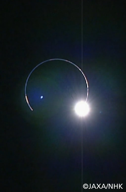
This photo was taken from a craft orbiting the moon, while the earth was between the moon (or at least the orbiting craft) and the sun. http://spacefellowship.com/News/?p=8229. WOW. People on earth would be seeing some degree of lunar eclipse, this says a penumbral eclipse. It's one thing to picture this, but it's gorgeous to see it.


http://www.kaguya.jaxa.jp/en/communication/com_information_e.htm#NEW_20090218A


(After I originally posted this, my husband pointed out a simple oversight on my part -- From the moon, this would be a solar eclipse, as the earth is occulting the sun. Were the people orbiting the moon seeing the moon's shadow on the earth, with the sun behind, that would be a terrestrial eclipse.)

It's more complicated than that

I don't know enough to know if there's a "right" and "wrong" in the Middle East anymore, beyond my strident belief that theocracy hurts people, but I think people do forget that it's more complicated than it appears on the surface, these days. The first half of the twentieth century is often forgotten.


This is a long video, nearly half an hour, about someone who was there at the time. I think it's important.

Tuesday, February 17, 2009

orca culture

I nearly popped with wonder at this video:


The surprise ending is astounding.

Geographers do it better?

It would strike me as odd if the various covert and overt government agencies trying to find Osama bin Laden hadn't tried some of the methods posited in this article, but I still like reading them, having them spelled out so specifically. What among these haven't we tried? Let's try them . . . and hang onto Peshawar, if we can.

From MIT:
In informal conversations in the Geography Department at UCLA, we began to ask ourselves if the biogeographic theories we use every day -– theories that predict how plants and animals distribute themselves over space and over time –- employed in conjunction with publicly available satellite imagery, could shed some light on this question. The outcomes of this musing, presented below, are our thoughts and experiment. By bringing these methodologies to bear, it is our hope that a long overdue debate might bring bin Laden back to the fore of the public consciousness – and possibly to justice*.


I find this sort of geography fascinating, but I also can't imagine wanting to do it.

*PDF article

Monday, February 16, 2009

Tokyo under grass

Me, I'm not that fond of so much lawn, if critters aren't eating it. I'd like to see half that much lawn, a whole lot of edible landscape, and perhaps native plants to attract wildlife -- but I'm a bit of a nutcase.

(More information and photomanipulated pics here - Tokyo is not really grassy like that.)

Sunday, February 15, 2009

Drought In California


Drought In California
Originally uploaded by Amicus Telemarkorum.
It's pouring outside right now. Pouring. I hear from my friends who didn't grow up here that it's miserable, it's raining too much. If it weren't a cold winter rain, I'd be dancing outside, probably naked.

This is a fierce drought, we're working our way into the third year of not-enough-water. The snow is shallow in the mountains, and that snow is our biggest reservoir. Folsom Lake, Lake Oroville, Lake Shasta, all are low, marinas are high and dry, because we haven't had enough rain and snow, our water's being shipped all over the state, including to rice farmers in the northern valley (when, in good years, rice growing replicates normal valley flooding, but in dry years, uses a lot of extra water) and to the west side of the lower San Joaquin Valley, where water-hungry crops grow on poor soils in near-desert.

Our population is growing, our climate is drying -- we do not have enough water.

It has been pouring, and the snow levels are low. It can continue to pour. I am fine with it.


More images here.

That's great, it starts with an earthquake, birds, snakes, an aeroplane. Lenny Bruce is not afraid.


meteor storm
Originally uploaded by eYe_image.
Phil Plait is requesting data about the fireball over Texas today, to track it and figure out what it was. If you are from Texas and saw it, or know someone who is or did, please go to his post at Bad Astronomy to report.

Saving power by saving water -- win/win for California


LA Aqueduct Cascades
Originally uploaded by Aquafornia.
There's a double whammy of fortune for folks who want to save electricity and water in California -- Peter Gleck, of the Pacific Institute, a global water research center, says that here in California, we can save electricity by conserving water.

We spend so much electricity shipping it around the state and drawing it up from the ground that using less will save power.

From WorldChanging at The Guardian:
The virtues of water efficiency can be found in California and China - regions where water shortages have become emergencies and droughts may worsen with climate change. Conditions may become more severe in the future as consumers turn to water solutions that often require even greater energy supplies.

In California, where drought is afflicting the land for the third year in a row, the state is reducing water deliveries by 20-30 percent this winter and warns of "the most significant water crisis in its history." The water shortages are forcing farmers to cut production and lay off employees in an already sour economy.

Meanwhile, water transportation, storage, and treatment account for about 19 percent of the state's electricity, according to a 2007 California Energy Commission report [PDF]. To reach the rapidly expanding urban clusters in southern California, for instance, water is pumped 2,000 feet (610 meters) over the Tehachapi Mountains north of Los Angeles.


Mind you, hydroelectric dams create electricity -- but that won't be reduced as we use less. And as the Sierra snowpack melts away with climate change, we will likely lose most of that reservoir, the snow itself, and have to find more ways to store water in our (ostensibly) wet winters to have enough to last us through our dry, dry summers. We'll either have to build a lot more dams, or find other ways to get (and save) water, and to generate power.

California's population is burgeoning, as well. We will, as a whole, want more water, not less, in future years -- and more power. By cutting back now -- growing dry-climate and native gardens, using landscaping water to grow our own climate-adapted food rather than lawns and privet hedges, moving California's crops into areas better suited for them, controlling water use in new developments, and other water conservation measures -- we can use less of the inevitable additional water, rather than more.

(Photo from Aquifornia)

Saturday, February 14, 2009

Friday, February 13, 2009

650 Million Years in 1 Minute and 20 Seconds

This is cool, and a bit dizzying, but I'm missing one thing: I thought the East African Rift would be pulling that continent apart along the rift zone. That's not illustrated here. What am I not understanding?


650 Million Years in 1 Min. and 20 Sec.

(Found on Matt's Geography Blog.)

Tuesday, February 10, 2009

Kids and the Ocean


photo Solitary Islands Marine Park


The Ocean Doctor continues on his quest to share the wonders of the ocean and its exploration and conservation with children all over the western hemisphere. His travels this year have brought him to South Dakota, Missouri, and Cuba. But he can't do it all without help. That much airfare, traveling food, and time off really add up.

If you can throw just a dollar or a bit more in the tip jar to help this science educator bring the ocean to children thousands of miles away from it, either literally or figuratively, please do. Check out his blog, see what he's doing, and find a way to help.

Thanks.

(the photo is not the Ocean Doctor -- I should ask him for a photo I can use, hm.)

Tuesday, January 27, 2009

Orphanage Bon Samaritain [03] Croix-Des-Bouques, Haiti

Dear Japan (and Northern Europe, etc.):

Instead of encouraging your citizens to make more babies in an overpopulated world, why not support healthy orphanages and education in impoverished countries, advocate ethical adoption of people from those places by your own people, fight racism at home, and thereby change the shape of your own demographics (so there will be young people to support your currently aging populations) without increasing global population?

Sure, it will dilute your racial stocks, but culture is learned, and you can raise a baby from Somalia or Bangladesh or Peru in your native cultures just fine.

Mary

Sunday, January 25, 2009

The American Geological Institute

When the bad guys can't stop giggling:

Rekindling the spark

David E. Guggenheim, The Ocean Doctor, has planned a massive expedition of teaching and discovery.

To celebrate his 50th birthday and awaken wonder about the ocean in children across the country, he intends to visit at least one school in each of the fifty states and the territories of the US to offer presentations, free of charge.

By inviting media and the extended communities of each school into the conversation, and encouraging the schools he visits to connect with each other, he plans to engage young people to develop the same energy students offered during the initial decades of the space program.

He's doing this on his own, but happily welcomes donations from folks who want to help send him on this journey of discovery. I hope it will be fruitful, fulfilling, and exciting for the kids, teachers, and communities -- and also for The Ocean Doctor himself.

More information (and the link to donate) is at The Ocean Doctor's own website.

Thursday, January 22, 2009

nobody living can ever stop me

When I was little, I learned a lot of geography from this song. "Mom, what do they mean by gulf-stream waters?" "What's a New York Island?" (I'd seen redwood forests, that much was easy.) I didn't know, nor did many people, that there are a full six verses, until I'd grown up.
Now, it's my all-time favorite patriotic song, and one of my favorite songs all together. There's an illustrated version for all six verses, I've given it to friends of all ages. But seeing Pete Seeger sing it, at nearly 90 years old, sent the tears pouring down my face.