


Thanks to my friend Lisa for pointing me at these badges.
(Admittedly, I only claimed the kid science one because these weren't available when I was little.)
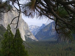
static : pulse from Samuel Cockedey on Vimeo.
I learned about buying sea creatures in the late ’70s at the sides of two old-time New Haven fishmongers who ran competing markets with differing styles. One brought in every fish he could find, mostly by going (or sending his help) to the Fulton Fish Market, Boston and Point Judith, R.I.
The other relied more on the trucks that worked the East Coast, going from fleet to fleet and market to market: A driver would start in Portland, Me., for example, with lobsters and scallops, and drive to Boston, where he might drop off lobsters and pick up cod and quahogs, then move on to Providence or Point Judith, where he would drop off whatever was in demand and load squid and swordfish. In New Haven he might find flounder. From there, he would hit New York, Cape May, Maryland, right down to Virginia or even Georgia or Florida. Then, his northern load diminished, his southern load — pompano, porgies, spots, snapper — in full supply, he would reverse the trip.
This makes me nostalgic. I may have missed out on the nickel-a-flounder days in New Haven, but I got to shop, learn about and cook fish at a time when my selections were varied and mostly local.
(I read the caption that accompanies this photo after I chose the photo for this post. Oh. See, these things also should be remembered.)


There are a lot of good reasons for girls to participate in Scouting, if they can find a good troop:
What else rocks about Girl Scouting?
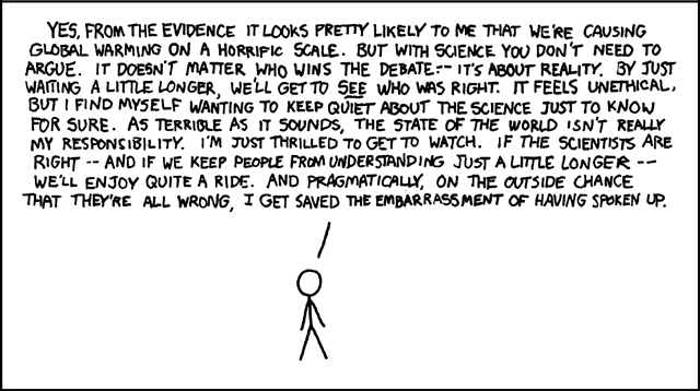
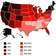
The United States seems inexorably headed towards marriage rights for [same-sex] -- but how long will it take to get there across the board? Nate Silver has an answer. Based entirely on his hard work at fivethirtyeight.com, here is the future of [same-sex] marriage in the US:
The years indicated are those by which a [same-sex] marriage ban would be defeated by voters in a given state, according to a regression model designed by Silver....
How did Silver come up with these results? Here's the explanation:I looked at the 30 instances in which a state has attempted to pass a constitutional ban on gay marriage by voter initiative. The list includes Arizona twice, which voted on different versions of such an amendment in 2006 and 2008, and excludes Hawaii, which voted to permit the legislature to ban gay marriage but did not actually alter the state's constitution. I then built a regression model that looked at a series of political and demographic variables in each of these states and attempted to predict the percentage of the vote that the marriage ban would receive.
It turns out that you can build a very effective model by including just three variables:
1. The year in which the amendment was voted upon;
2. The percentage of adults in 2008 Gallup tracking surveys who said that religion was an important part of their daily lives;
3. The percentage of white evangelicals in the state.

On June 1st, Michael Palin will be named as the new president of the Royal Geographical Society. The former Monty Python star has been travelling the world for more than three decades and says that his love of geography stems from school field-trips as a boy in Sheffield. He may therefore use his new position to promote geography in schools, previously arguing that the subject should be made “relevant, lively, stimulating, adventurous and…fun.
The Klamath Tribes and farmers have agreed to drop their state water rights battle pending approval of a federal agreement leading to removal of dams on the Klamath River.
The settlement filed Wednesday with the Oregon Department of Water Resources mirrors the water issues in the dam removal plan, known as the Klamath Basin Restoration Agreement.


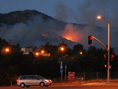
"Then without warning, the wind shifted, catching everyone by surprise. The shift was sudden and intense. Within a minute it switched from a 10-to-15MPH steady uphill breeze to 50MPH storm force winds heading directly down canyon."
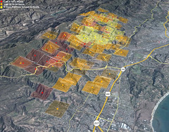
Google Maps has some LA Times coverage including where homes have burned, and links to stories.
[Google] is now facing inquiries from the Justice Ministry and angry accusations of prejudice because its maps detailed the locations of former low-caste communities."
[...]
Castes have long since been abolished, and the old buraku villages have largely faded away or been swallowed by Japan's sprawling metropolises. Today, rights groups say the descendants of burakumin make up about 3 million of the country's 127 million people.
But they still face prejudice, based almost entirely on where they live or their ancestors lived. Moving is little help, because employers or parents of potential spouses can hire agencies to check for buraku ancestry through Japan's elaborate family records, which can span back over a hundred years.
An employee at a large, well-known Japanese company, who works in personnel and has direct knowledge of its hiring practices, said the company actively screens out burakumin job seekers.
"If we suspect that an applicant is a burakumin, we always do a background check to find out," she said....
Lists of "dirty" addresses circulate on Internet bulletin boards. Some surveys have shown that such neighborhoods have lower property values than surrounding areas, and residents have been the target of racial taunts and graffiti. But the modern locations of the old villages are largely unknown to the general public, and many burakumin prefer it that way.
Google Earth's maps pinpointed several such areas. One village in Tokyo was clearly labeled "eta," a now strongly derogatory word for burakumin that literally means "filthy mass." A single click showed the streets and buildings that are currently in the same area.
Google posted the maps as one of many "layers" available via its mapping software, each of which can be easily matched up with modern satellite imagery. The company provided no explanation or historical context, as is common practice in Japan. Its basic stance is that its actions are acceptable because they are legal, one that has angered burakumin leaders.
It was Rumsey who worked with Google to post the maps in its software, and who was responsible for removing the
references to the buraku villages. He said he preferred to leave them untouched as historical documents, but decided to change them after the search company told him of the complaints from Tokyo.
"We tend to think of maps as factual, like a satellite picture, but maps are never neutral, they always have a certain point of view," he said.
Rumsey said he'd be willing to restore the maps to their original state in Google Earth. Matsuoka, the lawmaker, said he is open to a discussion of the issue.
I like reading maps and atlases written in different languages, both for the varying names of countries and features, as well as different words for basic map terminology.

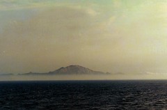
(Photo was taken in San Francisco yesterday. It's possible the sensor was in the sun.)
(11:09:33 AM) Me: Casey asked me if the strait of gilbraltar were closing or opening -- I didn't know for sure.
(11:09:42 AM) Kimberly: : heh, no clue
(11:10:01 AM) Me: So now: Would you like to know about the geology of northern africa and the african/eurasian plate boundary? I had to find out.
(11:11:02 AM) Kimberly: : of course I would like to know!
(11:20:10 AM) Me: *grin* The African plate is moving north pretty fast, but most of the compression is happening in (causing, in fact) the Atlas Mountains, not closing the straits.
(11:20:49 AM) Me: The straits gradually opened from about 25 million years ago to 5 myo, but have been slowly, slowly closing since, with most of the compression happening elsewhere in the mediterranean, local N. African mountains, and 45% of it in the Atlas Mountains.
(11:21:43 AM) Me: I said to Casey, "You knew I couldn't not know, once I realized I didn't know." Casey said, "I know. It means I don't have to do my own research."
(11:21:52 AM) Kimberly: : lol


