Rural school girl, San Augustine County, Texas (LOC)
Originally uploaded by The Library of Congress.
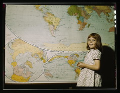
Some of the comments:
Man, look at French West Africa and French Equatorial Africa. I also see the Belgian Congo and the Union of South Africa.
Note the horn of Africa and the small country in northern Somalia. That's British Somaliland, which joined French Somaliland in 1960 to form Somalia. In 1991 when the civil war started, the old British Somaliland declared independence and has since maintained a stable, democratic government while the rest of the country languishes in an endless civil war. So far, no country except Ethiopia has recognized Somaliland, though there are rumors that recognition may be comming.
Note also that Burma (Myanmar) is part of British India. This may be an old map, I think the British had separated Burma by this time (though independence did not come until the late 1940's.) Burma had never historically been part of India and many Burmese were enraged when the British made it part of their Raj after overthrowing the monarchy in the 1880's.
Some of the notes:
"One Korea, spelled "Corea", and colored like Japan"
"Germany includes Austria, borders Italy"
"Ireland entirely part of Britain"
"French Indochina (no Vietnam, Cambodia, or Laos)"
"Manchuria (Manchukuo), Japanese puppet state"
"Note the horn of Africa and the small country in northern Somalia. That's British Somaliland, which joined French Somaliland in 1960 to form Somalia. In 1991 when the civil war started, the old British Somaliland declared independence and has since maintained a stable, democratic government while the rest of the country languishes in an endless civil war."
