Showing posts with label fire. Show all posts

Tuesday, September 01, 2009

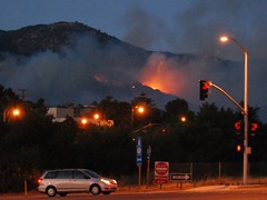
The Station Fire - this time with armageddon

For the next couple of winters, any storms with a lot of rain are going to make the San Gabriel range flow into debris basins and Pasadena.


After the Oakland Hills fire, officials sprayed the steepest hillsides with goo to glue the dirt together, mixed with wildflowers seeds - and the next few springs were stupendous. I'm not sure there's enough glue in the world for the San Gabriels, one of the fastest-rising and most fragile mountain ranges in the world -- but I hope they try something like that.

Thanks to Ian O'Neill for the pointer.

Saturday, August 29, 2009

Station Fire - August 29/30

From Eric Spiegelman, a time-lapse video of today's smoke from the Station Fire currently burning far out of control in the San Gabriel mountains of Southern California:

Time Lapse Test: Station Fire from Eric Spiegelman on Vimeo.


It's late and I'm sleepy, having paid too much attention to it today because a dear friend lives a couple of blocks outside of a mandatory evacuation zone. Things seem to be going reasonably well for her, in terms of how well the firefighters are protecting her little corner, but it's nerve-wracking.

The Briggs Terrace neighborhood is in worse shape -- okay for now, but transitions between night and day do weird things to weather and air circulation, and thus fire behavior.

Of course there are other fires burning in California. It's summer, after all.

That's the one capturing my attention right now.

Thursday, May 07, 2009

The Geography of the Jesusita Fire

Of all the fire articles I've read in a long time, this one caught my interest differently than the others, and I read it with a fresher eye.

Ray Ford's article in the Santa Barbara Independent looks a little at the rugged residents and the rock-tough firefighters, but it also touches on the wind, the topology, the vegetation, and other things that drive a fierce wildfire in California's chapparal.

This is geography. It's not just about what burns, or why, but about how it all works together, and anyone
who really wants to study fires, damage prevention, and effective fire-fighting in California probably knows all of this:
"Then without warning, the wind shifted, catching everyone by surprise. The shift was sudden and intense. Within a minute it switched from a 10-to-15MPH steady uphill breeze to 50MPH storm force winds heading directly down canyon."

And that, yesterday, is why the apparently mild-mannered Jesusita Fire went crazy, and is still out-of-control along Santa Barbara's northern flanks. The mandatory evacuation order includes areas just north and west of Santa Barbara's downtown. Flickr has plenty of pictures so far.

Google Maps has some LA Times coverage including where homes have burned, and links to stories.