Multiotuch Mapping Exhibit at Oakland Museum of California
Originally uploaded by ideum
The bottom floor, my favorite, was all about the California natural history, the river otters and acorn woodpeckers and bivalves in the bay mud.
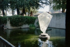
There was a gigantic relief map, and a huge whirling globe (in my icon!), and outside a koi pond with a big acrylic sculpture in it.
The green central (roof?) area sometimes hosted musical events, small festivals, wine-tastings. The lecture halls had a regular schedule of California-relevant educational events. The cafe was lovely, inexpensive for fairly good food, with a window above the pond, looking out into the peace.
Then it closed for awhile, for a deep remodeling. At first I was fussed that I couldn't attend, then I sort of forgot about it. When it half-reopened (the natural history section is due to open next year), I sort of forgot to go back.
Looking around for maps on Flickr tonight (I am a special kind of nerd) I found this little video about Ideum's interactive historic map display at the museum. OMG. The internet is indeed for (map) porn. I'm checking my schedule for the next week or so to find out when I should go to the newly reopened Oakland Museum of California.