When I was little, I learned a lot of geography from this song. "Mom, what do they mean by gulf-stream waters?" "What's a New York Island?" (I'd seen redwood forests, that much was easy.) I didn't know, nor did many people, that there are a full six verses, until I'd grown up.
Now, it's my all-time favorite patriotic song, and one of my favorite songs all together. There's an illustrated version for all six verses, I've given it to friends of all ages. But seeing Pete Seeger sing it, at nearly 90 years old, sent the tears pouring down my face.
Thursday, January 22, 2009
Thursday, December 25, 2008
Atlas of the Biodiversity of California
My mother-in-law gave me the Atlas of the Biodiversity of California for Yule/Christmas/Newtonmas. Yeah . . . I'll just be in my bunk.
(I'll review it later. First, I need to curl up in bed with a cup of tea and maps and photos and diagrams and geographic information.)
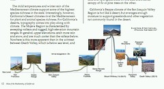
(I'll review it later. First, I need to curl up in bed with a cup of tea and maps and photos and diagrams and geographic information.)
Wednesday, December 17, 2008
whoops!
From wired.com:
I can imagine the drillers: "Whoops!" then the scientists: "Oh wait. Cool!"

Drillers accidentally hit a pocket of molten rock underneath a working geothermal energy field in Hawaii, a lucky break for geologists that could allow them to map the geological plumbing that created everything we know as land.
The unprecedented discovery could act as a "magma observatory," allowing scientists to test their theories about how processes transformed the molten rock below Earth's surface into the rocky crust that humans live on today.
I can imagine the drillers: "Whoops!" then the scientists: "Oh wait. Cool!"
Tuesday, December 16, 2008
AGU day 2 - no less tired
I didn't bring my little three-legged stool today because there's plenty of seating, and I dressed differently (with more willingness to be cold outside, too) so I have less to carry, so the day should be physically easier, right?
Or not. Because today, the exhibition hall was open, and boy oh boy, your tax dollars sure pay for swag. Do I need an image of the whole planet, as an anaglyph ("3-D"), complete with the viewing glasses? Define "need." I now have one. There are posters, and bookmarks, and postcards, and bound/published studies, and so much interesting stuff. I tried only to pick up free stuff I really, um, needed. So far, I've completely avoided all the book publishers, even the one that's half-price just for the conference, even though they have really, really neat stuff. So far.
This morning I attended a talk on challenges in California due to climate change, specifically why we're so fragile here, how our "perennial" agriculture (tree crops, grapes) will probably change and adapt, and mitigation and planning for sea level change in the San Francisco bay area. I know not everyone would say, "Wow, it was so interesting," but of course it was. I missed a presentation earlier this afternoon because of the information and sensation overload of the exhibition hall, and the rest required afterward, but am attending a presentation later today on "Science Issues for a New Congress and a New Administration." Then I think I'll call myself whupped, and head for home. Tomorrow is another day.
Monday, December 15, 2008
overwhelming - AGU Fall Meeting
I'm at the AGU fall meeting -- omg overwhelming. I don't have the stamina for all the poster stuff, I'm interested in 2/3 of them, but I don't understand 90% of those. I'm such a generalist. As I continue in school, I'll get more specific, I think continuing toward environmental studies and physical geography, and the teaching of it, and there are some great posters (and I'm anticipating some great speaker sessions) about that.
I love that I can hear languages from all over the world here, lots of Italians, also Russians, Germans, Koreans -- from what I've heard so far.
They've divided the sessions into four different locations within a two-block radius from one another, all posters in one big hall, booths in another, speakers upstairs from that, other presentations -- films, meetings, etc. -- into that.
It's actually very exciting, but again, I'm overwhelmed and though not quite out of my element, definitely still on the outskirts of it, working my way in.
( Maria: I actually hit the education posters for the morning right before I sat down and read your response to my last post. It's the direction I'm heading, I think, and I knew I'd be interested. Wish you were here! Thanks! )
Sunday, December 14, 2008
2008 AGU fall meeting -- tomorrow morning!
I'll be at the American Geophysical Union fall meeting in San Francisco all week, from early morning to late afternoon. I'm not an expert on anything, I'm just an earth sciences fangirl (and beyond, the AGU meeting covers most aspects of physical geography as well as solar system science) and struggled to list a primary interest at all. So far, going through the schedule and trying to establish an itinerary has been a huge challenge. There are, in some slots, two or three oral presentations and fifty or more poster sessions that I want to visit. I picked a lot of them by doing searches on "california," "san francisco," "bay area," "climate change," and "serpentine" -- then filled it in with whatever caught my eye. I'm trying to be firm with myself, then just make some last minute decisions while I'm there.
I'll blog, but I'm not sure how yet. I can either figure out how to mobile blog to this journal from my phone and do lots of small entries, or (and this is more likely) just use twitter a lot, and phone pictures to flickr or twitpic, and take pictures with my regular camera for later, then once or a few times over the course of the week, amalgamate those into a proper entry. Or maybe I'll do both. Do you have a preference?
Is there anything you'd specifically like me to explore, photograph, or write about for this blog, from the AGU meeting?
If not, my posts are likely to make it clear that I'm running around like the proverbial kid in the candy shop, licking everything and putting it back.
If I see the "seismologists are sinners" guy, I'll get a picture of him.
Sunday, December 07, 2008
Fun With Flickr
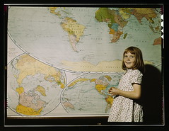
Rural school girl, San Augustine County, Texas (LOC)
Originally uploaded by The Library of Congress.
Some of the comments:
Man, look at French West Africa and French Equatorial Africa. I also see the Belgian Congo and the Union of South Africa.
Note the horn of Africa and the small country in northern Somalia. That's British Somaliland, which joined French Somaliland in 1960 to form Somalia. In 1991 when the civil war started, the old British Somaliland declared independence and has since maintained a stable, democratic government while the rest of the country languishes in an endless civil war. So far, no country except Ethiopia has recognized Somaliland, though there are rumors that recognition may be comming.
Note also that Burma (Myanmar) is part of British India. This may be an old map, I think the British had separated Burma by this time (though independence did not come until the late 1940's.) Burma had never historically been part of India and many Burmese were enraged when the British made it part of their Raj after overthrowing the monarchy in the 1880's.
Some of the notes:
"One Korea, spelled "Corea", and colored like Japan"
"Germany includes Austria, borders Italy"
"Ireland entirely part of Britain"
"French Indochina (no Vietnam, Cambodia, or Laos)"
"Manchuria (Manchukuo), Japanese puppet state"
"Note the horn of Africa and the small country in northern Somalia. That's British Somaliland, which joined French Somaliland in 1960 to form Somalia. In 1991 when the civil war started, the old British Somaliland declared independence and has since maintained a stable, democratic government while the rest of the country languishes in an endless civil war."
Friday, November 14, 2008
Bas Relief, American Geophysical Union (Washington, DC)
I just signed up as a student for the AGU fall meeting:
I had to answer the hardest question in the world.
It said, "Area of scientific interest: PICK ONE"
ONE????
*explode*

I had to answer the hardest question in the world.
It said, "Area of scientific interest: PICK ONE"
ONE????
*explode*
Saturday, September 27, 2008
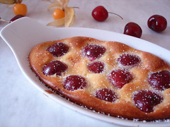
The geology of clafoutis
I rarely like posts with just links, so look, I'm adding words!
Please check out this post about the geology of clafoutis. It also touches on important issues such as pancake domes on Venus.
It is wonderful and makes me squee.
Thank you,
Mary
Please check out this post about the geology of clafoutis. It also touches on important issues such as pancake domes on Venus.
It is wonderful and makes me squee.
Thank you,
Mary
Thursday, September 25, 2008
eater of time
Our measurement of time is based on geography, and our knowledge of geography is based on time.
See?
Friday, September 12, 2008
boom de yada
Bad Astronomer writes:
I am a bit of a skeptic. I believe in science, I disbelieve in the supernatural. For non-traditional medicine, etc. I don't mind some anecdotal evidence, but I like to see science, I like to see things investigated. Sometimes the traditional stuff holds water, sometimes it doesn't. Acupuncture is showing actual results for a lot of conditions its used for (uterine support in conception/pregnancy, pain relief for chronic conditions, etc.) in scientific trials. Homeopathy hasn't held up as well.
In school and at home, when we don't teach children to think critically, when we don't ask them what they think will happen or why something happened, and when we don't give them the tool of questioning supposed experts, we fail them. They grow up assuming that the flash-illuminated, out-of-focus dust specks in the camera are ghosts, and don't buy the house they otherwise wanted, because they don't want to live in a haunted house. They make day-to-day decisions based on ancient, disproven myths. They miss out on timely medical help.
They don't question scientists when scientists should be questioned, it's integral to the process. Or they ask the wrong questions.
One reason I'm in this field is because I love the earth, I love the universe, and I don't need to have the world be supernaturally magickal to love it, there's enough magic in the natural. One reason I am in this field is to pass that on to children, with the tools to think about it rationally.

In India the other day, a young girl, distraught with fear that the world was ending when the LHC turned on, killed herself. She died, because she didn’t understand the truth.
Now that site is less funny, isn’t it? All over the world, in all different countries, people are raised to believe in superstitious nonsense, and raised to believe with all their hearts that it’s real.
And when we do that, we do far more than remove people from reality. We leave them vulnerable to all manners of nonsense, from believing in fairies to truly and honestly thinking the LHC will destroy the planet. People don’t learn how to think critically, and then they drink homeopathic water instead of taking real medicine, they chelate their children, or they deny their children vaccinations. And when that happens, people die. Children die.
I am a bit of a skeptic. I believe in science, I disbelieve in the supernatural. For non-traditional medicine, etc. I don't mind some anecdotal evidence, but I like to see science, I like to see things investigated. Sometimes the traditional stuff holds water, sometimes it doesn't. Acupuncture is showing actual results for a lot of conditions its used for (uterine support in conception/pregnancy, pain relief for chronic conditions, etc.) in scientific trials. Homeopathy hasn't held up as well.
In school and at home, when we don't teach children to think critically, when we don't ask them what they think will happen or why something happened, and when we don't give them the tool of questioning supposed experts, we fail them. They grow up assuming that the flash-illuminated, out-of-focus dust specks in the camera are ghosts, and don't buy the house they otherwise wanted, because they don't want to live in a haunted house. They make day-to-day decisions based on ancient, disproven myths. They miss out on timely medical help.
They don't question scientists when scientists should be questioned, it's integral to the process. Or they ask the wrong questions.
One reason I'm in this field is because I love the earth, I love the universe, and I don't need to have the world be supernaturally magickal to love it, there's enough magic in the natural. One reason I am in this field is to pass that on to children, with the tools to think about it rationally.
Saturday, September 06, 2008
Hurricane Hanna can cook
from the flickr site:
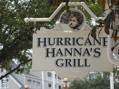
"Hanna produced tropical storm force winds and heavy rains across the U.S. Gulf Coast. In all, [Hanna] left $20.3 million dollars in damage and three deaths.
"Despite the damage, the name Hanna was not retired and is on the 2008 list."
http://www.nhc.noaa.gov/aboutnames.shtml
Friday, September 05, 2008
I think there may have been an earthquake
When an earthquake happens around here, you run and fill out the "did you feel it?" page -- FOR SCIENCE.
When you do that, among the questions is, "How did you respond?" You can choose between "No answer/don't remember," ""Took no action," "Moved to doorway," "Dropped and covered," "Ran outside," "Other." I mentioned to my partner, "They're missing one." He said, "Run to the computer and look up the quake on the USGS site?" "YES!" So I chose "other," and told them we ran to the computer, and that I thought from how it felt that it wasn't on the Hayward fault (it wasn't, it was on the Calaveras), and that I thought it was a 3.2 or so. Then I saw how deep it was and said, "That's pretty deep, it was probably a 4 or so." And bingo, I nailed it. I used far fewer words to explain this to the USGS.
(If you actually want to read the text in the image, which is a twitter-and-other-things friendfeed screenshot of folks responding to the quake, VIEW BIG.)
Thursday, August 28, 2008
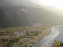
Along the Kosi
Until last week, the Kosi, a tributary of the Ganges, curved westwards out of Nepal in a C-shape. But in the torrential rains that have hit the region, the river burst its banks and diverted southwards through the state of Bihar, into a channel it had followed 200 years previously.
Satellite pictures
Where the rivers flow, and where harbors lie, is a major driver in human geography.
This is a very, very big deal.
(Only somewhat orthogonally, I'm reminded of John McPhee's description of the Atchafalaya's attempt to reclaim the Mississippi's water, in Control of Nature (how lucky we are that the New Yorker has archived that story for us), and how now, the US Army Corps of Engineers can't let the patterns of history, the switching back and forth of the main channel between the two rivers, continue, or it will leave New Orleans without its water highway.)
I don't think entropy's going to let us get in its way.
Tuesday, August 12, 2008
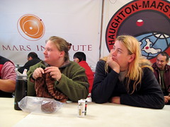
Mars on Earth
There's really no reason for this post except to say I love checking out the Haughton-Mars photos, and seeing friends of mine happily pretending they're on Mars and the moon. It was snowing today, up there, middle of the summer, below 0C. The arctic willows are turning red for the autumn, and the scientists are starting to return home for the season.
Flickr feed
Twitter feed
Oh: And these are my friends Sarah and Sarah. I envy the heck out of them. Sarah's knitting.
Flickr feed
Twitter feed
Oh: And these are my friends Sarah and Sarah. I envy the heck out of them. Sarah's knitting.
Thursday, August 07, 2008
Layers
Watching Battyden's short time-lapse of shifting cloud layers made me vaguely sad all of a sudden. A decade ago, I could watch this sort of movement over a period of time and roughly forecast the weather. One cool-not-cold April day in the eastern Sierra, I was sitting in the hot water of Grover Hot Springs, watching the clouds above me, and told my companion that based on what I was seeing, the temperature would drop 10-20 degrees over the next two hours, and we might get some precipitation. He laughed. We sat awhile longer, then each entered our respective changing rooms to get dressed to go eat dinner. A bit later, as I was tying my boots, the door swung open. Someone walked in wrapped in a coat, scarf, hat . . . and about a quarter inch of snow. While I'd been showering, drying off, and dressing, in maybe 20 minutes time, the clouds had thickened up, the temperature plunged, and the snows came down.
(A propos of completely nothing, at this point, I'd moved from Berkeley to Sacramento a few years previously, and yet, the snow-covered woman who walked in was an acquaintance of mine from Berkeley whom I hadn't seen in at least four years.)
I had a brilliant Geography 1 teacher, whom I keep meaning to write about, who got us excited about stuff like knowing how to forecast weather from observations, because he did, and now I've mostly forgotten the skill for lack of practice. I feel like I should go out into the country for a month and just pay attention. The bay area is actually painfully simple: It will be foggy and clear up, or it won't. If it does, the temperatures will rise; if it doesn't, they won't. It won't rain (much at all, sometimes some spitting) in the summer. In the winter, if it's cloudy it will probably rain, and probably quite a lot. If it's not, it won't. It's hard to see enough incoming weather to really forecast it, and it's often hard to see past the low fog to anything going on in the upper sky. Of course, I could always visit Wunderground, but that misses the point.
I need to get my body out there paying attention again.
Monday, August 04, 2008
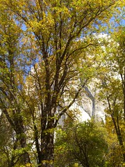
The East Bay hills from Coyote Hills
This photo reminded me that I need to start doing posts about places that spark memories and bring about an emotional response. I took this photo on my way back from Coyote Hills, in the East Bay Regional Parks system, last February. Coyote Hills is just north of the Dumbarton Bridge toll plaza, in Fremont. It's now a fairly well-developed wetlands park, with habitat for raptors, grassland mammals, deer, and everything that lives in marshes, including muskrats, fish, and birds such as bitterns. I saw a Chilean flamingo there, once, but I think it was an escaped exotic.
On this, the eastern side of the park, there has been huge fuss about development. How close can the houses come to the park? Just to the southeast of these houses, less than a quarter mile away across the road, is a big business park full of half-occupied buildings built just before the dotcom boom of the late nineties crashed. Not much farther away are condos and new subdivisions. Where will the wastewater go?
When I first visited Coyote Hills, Gerald Ford was in his waning days as president. It was hot that day (by bay area standards) and very windy, and there weren't big roads around here. There was no big highway 84, the Dumbarton Bridge was still a water-level toll bridge, and we rode our bikes from the very western side of Newark all the way up to around around the Coyote Hills, where there was almost nothing at all. It was hot and windy and I was out of shape and exhausted. It colored my experience of those hills so strongly that I resisted going back until about 1998, when I moved to the Fremont area, and re-discovered them.
I love them now, their bird life and the muskrats and the sunset view, and how the Coyote Hills are what remains of ancient mountain ranges, and are (along with the related Albany Hill) among the oldest hills in the bay area.
The houses on the hill in the far distance weren't there, when I first visited. Parts of the east bay hills are still getting paved over with streets, and houses are being sprinkled here and there, but mostly, the remaining hills are part of our green belt tradition, and I work to protect that, too.
Friday, August 01, 2008
Yosemite
Lynn Kendall says, about Ansel Adams' photos of Yosemite, and Yosemite itself:
I grew up in California, and always thought that Yosemite was an overpriced, overblown, overrated, crowded, hard-to-reach tourist attraction, not much else. I couldn't imagine what drew everyone there. I was sure Galen Rowell and Ansel Adams had photographed all there was to see, with skill that made it seem more than it was.
One morning in about 1993, my partner at the time and I woke up early for no real reason, a bit before dawn. There we lay, wide awake, and one of us -- I don't remember which -- said, "Hey, let's go to Yosemite!" So we jumped in the car and drove for a handful of hours, first on straight freeway, then on the winding "north entrance" highway up through Groveland, and we were there. It was February, and a warm day for the month. The air at Yosemite was perhaps in the 50s, with snow on the ground, but clear dry roads. The sky was bright blue. We got there at 8 am, and were among very few people in the park.
As you come in from the north, the initial view is almost startling. "Oh. This is what they mean." I was entranced. It was as if I was in a display, a dictionary definition of natural beauty. This is all real, these immense mile-high rocks, this exposed granite batholith. And that was the macro-park. I was also captivated by the tiny, the deep chocolate color and fuzzy caps of the goldcup oak trees, and the black oak leaf that lay on top of the snow and was warmed by the sun, sinking as the snow under it was melted, and sitting (when I found it) in the bottom of a six-inch-deep hole shaped exactly like a black oak leaf. But then the rocks, so big! They are there always. In the spring, some of the highest waterfalls in the world plunge down their faces. (At the top are emphatic warnings: If you go in the creek there, You Will Die.)
That day -- a pleasant weekday in February, few people, perfect weather -- was the best possible day for a visit to Yosemite. I've been there a handful of times since, sometimes with more people, sometimes fewer. I'm never let down. It is always amazing. It always makes me marvel at geology and geography, and the power of water (which, as ice, carved Yosemite into its present shape). It always makes me grateful for John Muir and his attempts to preserve it. I am always glad to live near enough to visit with relative ease.
You should go read Lynn's post about Yosemite, though. She says a lot more, and offers a lot more photos. :D
There are more great photos out there, including from Joe Decker, Buck Forester, David Morgan-Mar, pete@eastbaywilds, Denise Cicuto, and Sister Coyote. And I have a few more of my own.
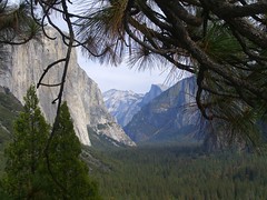
Powerful as [the photos] are, they can't evoke the sublimity of the place. I'm damned sure that I can't, either. That's why I've taken more than a month to even begin to fumble my way toward a post about Yosemite.
I grew up in California, and always thought that Yosemite was an overpriced, overblown, overrated, crowded, hard-to-reach tourist attraction, not much else. I couldn't imagine what drew everyone there. I was sure Galen Rowell and Ansel Adams had photographed all there was to see, with skill that made it seem more than it was.
One morning in about 1993, my partner at the time and I woke up early for no real reason, a bit before dawn. There we lay, wide awake, and one of us -- I don't remember which -- said, "Hey, let's go to Yosemite!" So we jumped in the car and drove for a handful of hours, first on straight freeway, then on the winding "north entrance" highway up through Groveland, and we were there. It was February, and a warm day for the month. The air at Yosemite was perhaps in the 50s, with snow on the ground, but clear dry roads. The sky was bright blue. We got there at 8 am, and were among very few people in the park.
As you come in from the north, the initial view is almost startling. "Oh. This is what they mean." I was entranced. It was as if I was in a display, a dictionary definition of natural beauty. This is all real, these immense mile-high rocks, this exposed granite batholith. And that was the macro-park. I was also captivated by the tiny, the deep chocolate color and fuzzy caps of the goldcup oak trees, and the black oak leaf that lay on top of the snow and was warmed by the sun, sinking as the snow under it was melted, and sitting (when I found it) in the bottom of a six-inch-deep hole shaped exactly like a black oak leaf. But then the rocks, so big! They are there always. In the spring, some of the highest waterfalls in the world plunge down their faces. (At the top are emphatic warnings: If you go in the creek there, You Will Die.)
That day -- a pleasant weekday in February, few people, perfect weather -- was the best possible day for a visit to Yosemite. I've been there a handful of times since, sometimes with more people, sometimes fewer. I'm never let down. It is always amazing. It always makes me marvel at geology and geography, and the power of water (which, as ice, carved Yosemite into its present shape). It always makes me grateful for John Muir and his attempts to preserve it. I am always glad to live near enough to visit with relative ease.
You should go read Lynn's post about Yosemite, though. She says a lot more, and offers a lot more photos. :D
There are more great photos out there, including from Joe Decker, Buck Forester, David Morgan-Mar, pete@eastbaywilds, Denise Cicuto, and Sister Coyote. And I have a few more of my own.
Xi'an, Total Solar Eclipse at Sunset
From western Siberia:
It really is amazing, how much some people love eclipses. My partner and I travelled to England with his mother to see one, once. A few years later, she toured South Africa to see a total eclipse. I wish I could have gone then.
It was cloudy on Devon Island, but the Haughton Mars Project still experienced their first total darkness all summer. They have a Flickr set to show you what it was like. The research team is only there in the summer, so for most of those folks, the eclipse was the first time they've been to Devon Island in the dark. Elaine at HMP says there will be an edited video later.
Flickr is full of pictures. I love this one from Norway.

Traffic stopped. Crowds wearing protective eye wear cheered and whistled as the moon covered the sun, the wind died and day became night.
Lucas Heinrich, a physics student from Berlin who traveled to Novosibirsk with classmates, described the eclipse as "unbelievable."
"It became cold and dark, and suddenly it was light again. I am very happy — it was worth the trip," Heinrich said.
It really is amazing, how much some people love eclipses. My partner and I travelled to England with his mother to see one, once. A few years later, she toured South Africa to see a total eclipse. I wish I could have gone then.
It was cloudy on Devon Island, but the Haughton Mars Project still experienced their first total darkness all summer. They have a Flickr set to show you what it was like. The research team is only there in the summer, so for most of those folks, the eclipse was the first time they've been to Devon Island in the dark. Elaine at HMP says there will be an edited video later.
Flickr is full of pictures. I love this one from Norway.
Tuesday, July 29, 2008
Getting to the bottom of this
Russia wants to go to explore the bottom of Lake Baikal:
"Russian officials hailed the five-hour expedition, due to take seabed samples and document Baikal's unique flora and fauna, as a new chapter in Russian science."
I'm all about exploration, but somehow, I found myself thinking, "Wait, that's private, maybe there are some things we shouldn't know." And I can't explain that reaction. I'm sure that I can logic my way out of it. It was a knee-jerk response.
I thought, "I'm not sure I'd want them to poke around on the bottom of Crater Lake like that," then thought, "Have they? . . . ." I wasn't sure. So I poked around in a web search and found out that yes indeed they have, then I got all interested in that science, and forgot that I was squeamish about scientists poking around on the bottom of Crater Lake, and that learning more about places (and things, and people) we love can be a good thing, as long as we don't hurt them (much) in the process.
Subscribe to:
Posts (Atom)
