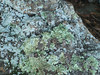
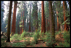
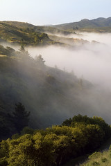
The notes and comments on this flickr page make me ridiculously happy!
Friday, June 27, 2008
Thursday, June 26, 2008
Losing California
From Science Daily:
The native plants unique to California are so vulnerable to global climate change that two-thirds of these "endemics" could suffer more than an 80 percent reduction in geographic range by the end of the century, according to a new University of California, Berkeley, study.Because endemic species -- native species not found outside the state -- make up nearly half of all California's native plants, a changing climate will have a major impact on the state's unparalleled plant diversity, the researchers warn.
(There's much more at that link.)
The illustration they use for this story is a range map for the California Bay tree, Umbellaria californica, one of those trees of my childhood about which I get emotional. I was delighted when Botany Photo of the Day published some of my photos of local bay trees. You can see, in the illustration, how California's island ecology can shape an organism's range. In this case, the deserts of southeast and northeast California and the Sierra Nevada keep the California Bay (which is also called Bay Laurel or Pepperwood in various parts of its range) up against the coast and in the foothills around the valley. That map seems to suggest that with dispersal over the course of climate change (and how would that happen? people?) the range can remain perhaps large, even as range is lost due to change.
In my own head, I've been pondering the future, and whether it makes sense to simply watch some of the endemic organisms of California die off as climate changes, being as it's so much harder for anything to adapt than it used to be -- where will they go? we've fragmented habitat such that animals and annual plants can't move as they used to, and trees shift range slowly even in good circumstances -- or whether they should have human help, being as they'd mostly be displacing or joining organisms who will also need to move as their own climates change. Does it make sense to help move California bay, redwood, douglas iris, valley oaks, and other California-adapted organisms into more hospitable locations for them? Will failing to do so decrease biodiversity across the ranges of what lives in California and Oregon now? What's happening now will affect biodiversity in both areas anyway. The lands north of us will either lose or need to help move its endemic life. Regardless, the richness will become less rich.
Monday, June 23, 2008
California's a little hot right now
The Firefighter Blog links to a June 23 satellite image showing smoke from fires all over Northern California. This blogger says that the remnants of the Wild Fire along the Napa/Solano County line is visible; I can't see it. But I can see columns of smoke rising in Mendocino, Shasta, Monterey, Butte, and Trinity Counties, at the very least. Anywhere structures, people, farms, etc. aren't threatened, the fires are being left to burn, which makes a lot of sense given how California's ecosystems evolved to be healthier in the presence of fire. After this last weekend of dry thunder storms, most of the fires are lightning-started, but at least one of the big fires this past week was an arson fire.
Aside from the alpine and northwest corner rainforest ecosystems, California's endemic plant life is fire-adapted. Once manzanita is 15 or 20 years old, it's unhealthy. When fire approaches, it bursts into flame; after a fire, the manzanita regrows, healthy and young, from the rootstock. Bishop pine cones open properly only in real heat. I once took part in a seedling-count for a study of plant regeneration after the Vision Fire on Point Reyes. There were many times -- in places, ten times or more -- more Bishop seedlings under burned trees than in unburned areas, in April, because Bishop pine cones open in heat, open when fire is burning under them. In fact, on the whole, the burned out areas are healthier than ever. Redwood trees seed on bare mineral soil, but shed a lot of duff. Their seeds sprout best on soil that's been brought to bare dirt by flood or fire. We need to burn here. But with so many people in wooded and brushy areas, now, we can't let every fire burn, and some of our wildlands have had fire suppressed for so long that when they finally burn, it will be with devastating heat and height.
California's a beautiful place, but here, nature seems to like to remind us we're not in charge, and only sometimes know what we're doing.
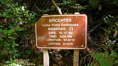
Loma Prieta Earthquake Epicenter
Joe found this sign (and didn't photograph it, but found a pic on flickr) while out hiking yesterday. Someone has corrected the originally reported intensity, and Richter measurement, 7.1, to the Moment Magnitude measurement, 6.9.
He pinged me in IM: "That wasn't you, right?"
No. That wasn't me. :)
He pinged me in IM: "That wasn't you, right?"
No. That wasn't me. :)
Friday, June 20, 2008
Happy Solstice, everyone!
I'm a bit of a dork, and wanted to share this today, especially:
World night/day clock. Of course, I'm posting this while the curve is as horizontally flat as it can get, but it will change over the next six months until it has two near-vertical lines.
I'm a skeptic/atheist/agnostic, really, but without theism, I'm still very emotionally and spiritually tied to how the cosmos, the solar system, and the earth all works together. I don't need to have a supernatural point of view to think solstice is really cool.
I love loving the earth, and marveling at it, and I like to hang out with people who feel the same way. I love the universe on its grandest scale, I love the interactions and lifecycles of the galaxies and stars. I love the history of the solar system and the earth, and the intricacies of meterology, and the story behind glaciation. I love the compostion of sand on a beach. I love that solstice matters to people.
It all works together. It feeds me.
How do you feed that side of yourself?
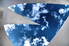
The image is a looking-up shot of the Sundial Bridge, in Redding, California. The bridge is near where I grew up, alongside the park where I spent most Independence Days, running around on the grass, finding the dunking booth, and after sunset, watching fireworks over the river. There was controversy and cost over-running and fuss about its being built, and it was possible to wreck a pretty stretch of river with that bridge, but they did good.
When I was little, I watched Redding grow from 10k to 20k people through annexations and population growth. Now, with more annexations, and more population growth, there are about a hundred thousand people in Redding. I don't like the effects of the sprawl, with oak woodland mowed down for parking lots and housing tracts, and the local lakes and rivers taking a water quality blow. (Water quality started to suffer 150 years ago, when the first mines were put on Sacramento River tributaries.) But I'm glad that if they have to grow, they're growing with some style and elegance, and a nod back to the earth.
World night/day clock. Of course, I'm posting this while the curve is as horizontally flat as it can get, but it will change over the next six months until it has two near-vertical lines.
I'm a skeptic/atheist/agnostic, really, but without theism, I'm still very emotionally and spiritually tied to how the cosmos, the solar system, and the earth all works together. I don't need to have a supernatural point of view to think solstice is really cool.
I love loving the earth, and marveling at it, and I like to hang out with people who feel the same way. I love the universe on its grandest scale, I love the interactions and lifecycles of the galaxies and stars. I love the history of the solar system and the earth, and the intricacies of meterology, and the story behind glaciation. I love the compostion of sand on a beach. I love that solstice matters to people.
It all works together. It feeds me.
How do you feed that side of yourself?
The image is a looking-up shot of the Sundial Bridge, in Redding, California. The bridge is near where I grew up, alongside the park where I spent most Independence Days, running around on the grass, finding the dunking booth, and after sunset, watching fireworks over the river. There was controversy and cost over-running and fuss about its being built, and it was possible to wreck a pretty stretch of river with that bridge, but they did good.
When I was little, I watched Redding grow from 10k to 20k people through annexations and population growth. Now, with more annexations, and more population growth, there are about a hundred thousand people in Redding. I don't like the effects of the sprawl, with oak woodland mowed down for parking lots and housing tracts, and the local lakes and rivers taking a water quality blow. (Water quality started to suffer 150 years ago, when the first mines were put on Sacramento River tributaries.) But I'm glad that if they have to grow, they're growing with some style and elegance, and a nod back to the earth.
Thursday, June 12, 2008
It's an "interesting" year, weather-wise
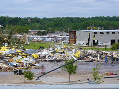
When I'm reading a story that's actually making me cry (about a tornado hitting a boy scout camp and killing four boys, but also about the way the scouts handled themselves in the aftermath), it's really a cognitive disconnect to laugh out loud to read that the building that was destroyed at Kansas State University in Manhattan (KS) was the wind erosion lab.
In all seriousness, yesterday's tornado outbreak was horrible, and it's looking already to be a fierce and memorable and tragic year for tornados in North America.
In all seriousness, yesterday's tornado outbreak was horrible, and it's looking already to be a fierce and memorable and tragic year for tornados in North America.
Wednesday, June 11, 2008
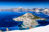
How Crater Lake was formed, in four parts
Swiped from Green Gabbro. Totally.
(more detail)
Crater Lake is one of the most beautiful places in the world. It's a bit off the beaten track, but worth your trip. Bring your camera. In the winter, bring your cross-country skis.


(more detail)
Crater Lake is one of the most beautiful places in the world. It's a bit off the beaten track, but worth your trip. Bring your camera. In the winter, bring your cross-country skis.
Thursday, June 05, 2008
The Start
Billions of dollars pledged for food fight
I am simultaneously amused by the phrasing, and startled at the dichotomy between a world where "enough food" isn't a daily reality for billions of people, and yet, we throw it at each other.
I am simultaneously amused by the phrasing, and startled at the dichotomy between a world where "enough food" isn't a daily reality for billions of people, and yet, we throw it at each other.
Thursday, January 17, 2008
Rural school girl, San Augustine County, Texas (LOC)
Rural school girl, San Augustine County, Texas (LOC)
Originally uploaded by The Library of Congress.
The Library of Congress now has a flickr account.
They need folks to add tags to their pics, and only two, when I searched, say "geography." I'm sure there are more in there that are relevant. We just need to fix it.
Tuesday, October 30, 2007
The End of the Mothball Fleet
I grew up riding to the bay area in the family car at least twice a year. I was raised in Shasta County, up north, but Mom's best friend lives in San Leandro (about two miles from where we live now, she still lives in the same house she's lived in since the fifties) and my aunt lived in Palo Alto, so we'd come down for a couple of weeks every summer, and sometimes for Christmas or another break. Until the early seventies, we had no air conditioning, and in the summer, at least half the ride down is in temperatures over 90 or 100F, so Mom would load the car at night, toss the luggage (around the edges) and some pillows and blankets into the back of the station wagon, and toss me and my sister back there for the ride. I guess we'd leave the house around 3 or 4 in the morning, because my sister and I would wake up at sunrise, usually just in time for what Mom called "the mothball fleet." For me, that and the C&H sugar factory in Crockett were "now entering The Bay Area." Mom told us that the Navy always intended to re-use those ships, and that they were parked where they were because they had easy access to the ocean, but that the water in Suisun Bay wasn't as salty as that farther down into San Francisco Bay. I just loved them. For awhile, the Glomar Explorer was parked with them, that was exciting.
It never occurred to me until a few years ago that the ships were sitting there polluting the bay, though I knew that most of them couldn't possibly be reused now, fifty years after they were first moored. They're falling apart. To make them suitable for scrapping will mean doing things to them that will cause further water pollution. Are we just screwed?
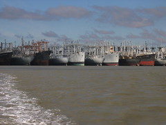
It never occurred to me until a few years ago that the ships were sitting there polluting the bay, though I knew that most of them couldn't possibly be reused now, fifty years after they were first moored. They're falling apart. To make them suitable for scrapping will mean doing things to them that will cause further water pollution. Are we just screwed?
Tuesday, October 23, 2007
Southern California is burning

Link list for mapping the southern California fires.
The LA Times and the OC Register are both using Google maps, natch.
Among the thoughts that keep cropping up in disorganized ways, for me:
1) It's scary and nauseating, how sociopathic arson is: "The fire broke out just as the Santa Ana winds were picking up. At one point, it flashed through three miles of parched-dry brush in less than 30 minutes.
"Whoever did this knew what they were doing," said Kris Concepcion, a battalion chief with the Orange County Fire Authority.
2) People continue to build homes in fire-prone (in California, it's fire-adapted, the ecology is healthier for regular, moderate fires) areas, and losing them.
3) If folks who are predicting the specific changes related to climate change are correct, wildfire seasons like this will get worse rather than better over the next century.
Wednesday, September 26, 2007
Three Gorges Dam pisses me off
I used some pretty colorful language when I first heard about this:
and
and
Geological instability isn't the only unforeseen negative effect of the Three Gorges. Downstream of the dam, locals have been battling two billion rats forced into farmland by rising water levels after the dam authority released a large amount of Yangtze River water "to control flooding in the face of the annual rainy season".
Two billion rats.
People have been crying about this for years. A friend of mine in the early nineties, while in her mid-sixties, took a boat tour down the gorge because she thought she'd never have another chance to see it if she didn't go now. People have said we'd lose the river dolphin, for years. People have warned against pollutant build-up in the water, where folks get water for cooking, and bathe their babies. They worried about whether silt would fill the basin too fast, given how muddy the Yangtze is, or that the silt and other materials carried downstream would damage the turbines. They rallied against corrupt officials mishandling the funds used to relocate people, and of people whose rich farmland on which their families had worked for hundreds of years would be flooded, while they were given rocky hillsides as compensation. They raised a fuss about the drowning of barely visited or newly discovered archeological sites, of the loss of historic temples, of the effect on the people below if something happened to breach the dam. But there wasn't anything anyone could do to stop this dam.
Now that the damage has largely been done, they admit that there could be problems.
I just want to kick somebody.
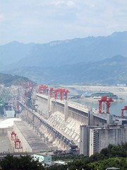
In unusually frank language, Chinese officials publicly acknowledged "hidden dangers" at the massive Three Gorges Dam, including landslides, erosion and pollution that could lead to an environmental disaster if not quickly fixed.
"If no preventive measures are taken, the project could lead to catastrophe," the official Xinhua news agency said on its English-language newswire, paraphrasing experts speaking at a conference this week. As an indication of the government's sensitivity to the issue, that phrase wasn't included in all versions published by Xinhua.
and
It was hailed as one of the engineering feats of the 20th century. Now the Three Gorges Dam across China’s mighty Yangtze River threatens to become an environmental catastrophe.
and
"We cannot lower our guard against ecological and environmental problems caused by the Three Gorges project," Wang Xiaofeng, director in charge of building the dam, was quoted as saying. "We cannot win by achieving economic prosperity atthe cost of the environment."
Geological instability isn't the only unforeseen negative effect of the Three Gorges. Downstream of the dam, locals have been battling two billion rats forced into farmland by rising water levels after the dam authority released a large amount of Yangtze River water "to control flooding in the face of the annual rainy season".
Two billion rats.
People have been crying about this for years. A friend of mine in the early nineties, while in her mid-sixties, took a boat tour down the gorge because she thought she'd never have another chance to see it if she didn't go now. People have said we'd lose the river dolphin, for years. People have warned against pollutant build-up in the water, where folks get water for cooking, and bathe their babies. They worried about whether silt would fill the basin too fast, given how muddy the Yangtze is, or that the silt and other materials carried downstream would damage the turbines. They rallied against corrupt officials mishandling the funds used to relocate people, and of people whose rich farmland on which their families had worked for hundreds of years would be flooded, while they were given rocky hillsides as compensation. They raised a fuss about the drowning of barely visited or newly discovered archeological sites, of the loss of historic temples, of the effect on the people below if something happened to breach the dam. But there wasn't anything anyone could do to stop this dam.
Now that the damage has largely been done, they admit that there could be problems.
I just want to kick somebody.
Sunday, August 26, 2007
Google Earth Science
This is just pure smut, for the likes of me:
Designing and Creating Earth Science Lessons with Google EarthTM
It's like . . . . oooh. I'll be in my bunk.
I'd love to sit with a patient child or adult, with Google Earth, and talk about what it illustrates. It reminds me of lying on the floor over the atlases, when I was little.
Designing and Creating Earth Science Lessons with Google EarthTM
It's like . . . . oooh. I'll be in my bunk.
I'd love to sit with a patient child or adult, with Google Earth, and talk about what it illustrates. It reminds me of lying on the floor over the atlases, when I was little.
Sunday, August 12, 2007
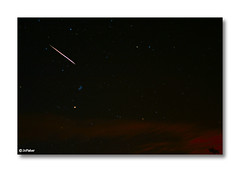
The Perseids
When I was a little girl, August was a scorcher where I lived, and we had a tiny, hot house. When it became too hot to sleep indoors, we'd spend a few nights outside on the lawn, in sleeping bags, and Mom would show us the constellations and tell us their stories. And right smack in the middle of August, we'd watch shooting stars. Shooting stars are always best in August, Mom told us. We'd stare and stare at the sky until we fell asleep, then wake at dawn.
They have a name now -- Perseids.
They have a scientific explanation. Mom told us they were rocks that flew through space and heated up when they went through our air, and that they almost never hit the earth because they burned up and were gone before they hit the ground. That's all we knew, and that was all that mattered, when I was six or so and sleeping on the lawn.
Sunday, August 05, 2007
quickie - SF after the big quake
Strangemaps shows San Francisco immediately post '06 quake. I love comparing old geography to modern geography, to see how humans have changed things. Look how China Basin once had so much water, and is now mostly filled in.
The epicenter (long thought to be at Olema, at the neck of Point Reyes) was actually a bit left of where the P in "Pacific Ocean" is, on this map, just offshore where the San Andreas goes into the sea near the Daly City/SF line.
Earthquakes simultaneously fascinate and terrify me. I can read just so much about them, and then I have to stop. Seismology is one of my favorite hobby fields, but I don't think I could study it as a focus in geology without becoming a gibbering mass of anxiety.
Sunday, July 29, 2007
An Island Called California
"It is known that to the right of the Indies there exists an island called California very near the terrestrial paradise; and peopled by black women among whom there was not a single man since they lived in the way of the Amazons.
They had beautiful robust bodies, spirited courage and great strength. Their island was the most impregnable in the world with its cliffs and headlands and rocky coasts. Their weapons were all of gold . . . because in all the island there was no metal except gold.
And there ruled over that island of California a queen of majestic proportions, more beautiful than all others, and in the very vigor of her womanhood. She was not petite, nor blond, nor golden-haired. She was large, and black as the ace of clubs. But the prejudice of color did not then exist even among the most brazen-faced or the most copper-headed. For, as you shall learn, she was reputed the most beautiful of women; and it was she, O Californias! who accomplished great deeds, she was valiant and courageous and ardent with a brave heart, and had ambitions to execute nobler actions than had been performed by any other ruler — Queen Califia." -- from
Las sergas de Esplandián by Garci Rodríguez de Montalvo
Yesterday, StrangeMaps showed us a 15th Century map from China that shows what could even be Australia and New Zealand, as well as the classic Island of California off the west coast of North America. This map was created long before Columbus, Magellan, or Drake sailed the seas. Look how similar the continental boundaries are to today's maps, how well the coasts match what we now know.
Though California isn't an island (it's probable that the opening to the Gulf of California and perhaps the Columbia River made it seem so), Elna Bakker used the idea for her book, Island Called California, about California's unique "island ecology." Because we have an ocean to our west, a high mountain ranges to the north and east (with those on the east backed by desert), and desert to the south and southwest, much of California's land is ecologically like an island, with endemic organisms of all sorts. Our magpies have yellow bills, our sequoias are unique, we have lilies and salamanders like no others. To be honest, as much as part of me supports the division of California into two states, a bigger part of me wants not to break that poetic island, to distribute yellow-billed magpies between two states, or to either divide or simply give up the sequoias as "my own."
As California changes with the climate, some of the animals -- amphibians and more delicate herbaceous plants, especially -- will have no place to go. The same barriers that allowed them to develop in unique ways will largely prevent them from adapting by gradually shifting their ranges elsewhere. Around the world, humans have made barriers of their own, as well. Plants and animals can't adapt by moving through farm belts, urban areas, or across new desertified regions, either. We are banishing our wildlife to islands to make do with what they have.
Friday, July 20, 2007
What California looks like
I noticed, while driving up I-580 west of Dublin, California (which is becoming a maze of condos and office buildings and supermarkets, Dublin is doublin') that the golden summer grass is becoming brown a little early. I'm the first to say "no, it's golden," when someone says that our summer grass is brown. It's golden. But it becomes brown, eventually, as the golden stems of dry grass bend over, and flatten, and more dirt is exposed. I usually start noticing the brown in mid- to late August, sometimes September, and the brown lasts until the first real rainstorms germinate more grass seed. Our last rainy season was abbreviated and light, it's a dry summer.
It's one of those things that means California, to me, the shifting colors of the grass (white isn't the winter color, here on the coast, green is), and the hallmarks of what we call seasons.
Lynn Kendall, in Unnatural History, discusses coming to California, and how much the local geography influenced her decision to move here from Pennsylvania, and ultimately, to stay here.
I remember my wonderful Sacramento City College geography teacher, years back, telling me that he decided to stay in California after he first visited from New England and saw a redwood tree and a palm growing side-by-side. (Of course, both were planted, our redwoods come from the northwest coast of the state, while the Washingtonia palms are from the southern deserts. But still.)
What does California look like to me? It looks like rolling golden hills, buckeyes that turn brown in July, broccoli-shaped oak trees, patches of bare serpentine soil in the dirt of the coastal hills, Sonoma County's cold and rocky beaches, gray pines above the chaparral. Sometimes it looks like exposed granite batholith, or lava tubes, or high meadows full of crimson columbine and beautiful purple shooting stars, or the grey-and-white cone of Mount Shasta. But mostly, it's our rolling foothills, our fire-adapted woodlands, golden California.
Friday, July 06, 2007
weather report
It reached 111.8FC/44.3, yesterday, in my old neighborhood in Shasta County, California. Last time I was through there, I went up to Whiskeytown Lake to camp and swim, as it was cooler there than in town, at only 115F. It was 118F in town. I remember 119F at least once when I was little, but not higher. The official highest ever in Redding is lower -- 118F, maybe, or 116 -- but local temps vary, of course, and I remember 119F. We got 119 the same year that our winter snow was so heavy that a Thrifty drug store and the roller skating rink caved in, and my mom made my brother go shovel off the flatter parts of our roof every single day. That would have been 1969 or 1970, I think, as my sisters were hanging out at the local hippie house, at the time, and they tried to cook an egg on the sidewalk there.
So many of my memories aren't attached to specific dates and years, but are attached to when songs were on the radio, or when people around me were doing particular things.
So many of my memories aren't attached to specific dates and years, but are attached to when songs were on the radio, or when people around me were doing particular things.
Wednesday, June 13, 2007
Geographilia as a calling
In the early nineties, I took a geography lab from the best geography teacher I’ve ever had, at the best community college I’ve ever attended.
The class was sheer fun. For our first field trip, he asked us each to find cross country skis or snow shoes, then brought us up to Lassen Park in April, when the road was still closed by deep snow. We’d spent some time learning how to take field notes, find directions, and other elements of geography field work, and when we arrived at the park, someone asked, “Is there anything special we should be noting?” He replied, “No, really, I just wanted you to see what Lassen is like before the road opens.”
It was quiet, and everything was white. The fumaroles steamed from underneath the snow. He warned us about the hollows that melted out around the fumaroles, capped by snow, and told us about participating in the rescue (because he works in Lassen back country rescue, did then, still does) of a man who had fallen face down into a pit, and would suffocate down there if someone couldn’t get their face down there and provide him some rescue breathing until help could arrive to pull him out, which was considerably later.
He pointed out mountain chickadees by their calls, and explained the geology of the mountain. The joy he felt in this snowy park – his place, which he knew intimately, and wanted to share with us – was palpable to the point of magic.
Everything about that class, and its prerequisite basic physical geography classroom course, seemed to be because the teacher thought it was cool, that he wanted us to see these neat things he thought were cool. From him I learned how rare the Mediterranean climate type is, and he shared with us that he first settled in the Sacramento Valley, in the sixties, because he crossed the Sierra and saw a redwood tree and a palm tree growing side by side, and was charmed. When we learned about weather patterns over and currents within the ocean, he told us about his summer fishing in Ireland, when a hurricane in the Caribbean managed to send lobster pots up the Irish rivers. He spent a big part of one class playing us an NPR show about people who had been struck by lightning and survived.
That magic hooked me. That magic sucked me into geography as a field, something I could do, rather than a dry high school course where we figured out adiabatic cooling rates.
Geographiles would be a lot better off if more people who are captivated by the magic would actually teach it, write about it, and share what we love. Perhaps that’s a call to action.
Monday, June 11, 2007
Sense of place: Climate
I grew up in a Northern California town where we had wet winters, hot dry summers, and mostly dependable weather. It wasn't quite mediterranean, like the San Francisco bay area. Winters were colder, we had snow now and then in the winter, sometimes deep enough to sled in, sometimes lasting a week or more. Summers were hot, with three-digit days unsurprising.
Last time I was there, it was 118F in town, so I took refuge at the lake, where it was only 115, and camped out that night with no tent, lying on top of my sleeping bag, and only a sheet over me all night, to keep mosquitos off.
In seventh grade, I moved to the San Francisco bay area. I remember very clearly waking up on my first school morning there, to walk the mile or so to school, and needing a sweater. It was grim out, and I hated it, and was immediately homesick. But like on most days, it cleared up by 10 or so, and was bright and not too warm after that.
It was springtime in the bay area, and cool, with a thick marine layer. These days, still living in the area (after forays into other parts of the state, and one other country), I often appreciate the fog in the morning, it can easily keep a summer day below 80F. From late July to early September, the sea warms up enough that we lose the layer, and it can get quite hot here.
Last week, I got back from my third visit to New England. The first time we were there, just after summer solstice, it was 100F and 95% humidity. Folks told me it was unseasonably warm. I got sick. It was horrible. I wasn't used to it. Other people there were used to it, and while not happy, managed. This last time, it was less hot, but warm enough, and I went hiking at Middlesex Fells Reservation. It was truly lovely, but the sweat never dried on my back. Stilll, I remember thinking, "Everything is green, and this is nice, but it's stickky. It's not my weather."
I'm so rooted in central California, now, this weather is my weather. I've always lived in in the SF Bay Area or north, within California. Though I've lived in a geographically broad range of places within California, they've still always been in the Mediterranean climate zone, and when I lived overseas, in Australia, I managed to end up on the edge of the tiny portion of Australia that has a Mediterranean climate.
But when I change climates -- on a small scale, from Shasta County to the bay area, or on a larger scale, from the Bay Area to Massachusetts, I am thrown for a loop. The biggest blow to my sense of place is usually how the are around me feels, compared to how I expect it to feel, how the weather behaves, whether I carry an umbrella.
Subscribe to:
Posts (Atom)
